The Pico Anticline, Santa Susana Mountains, Los Angeles County, California
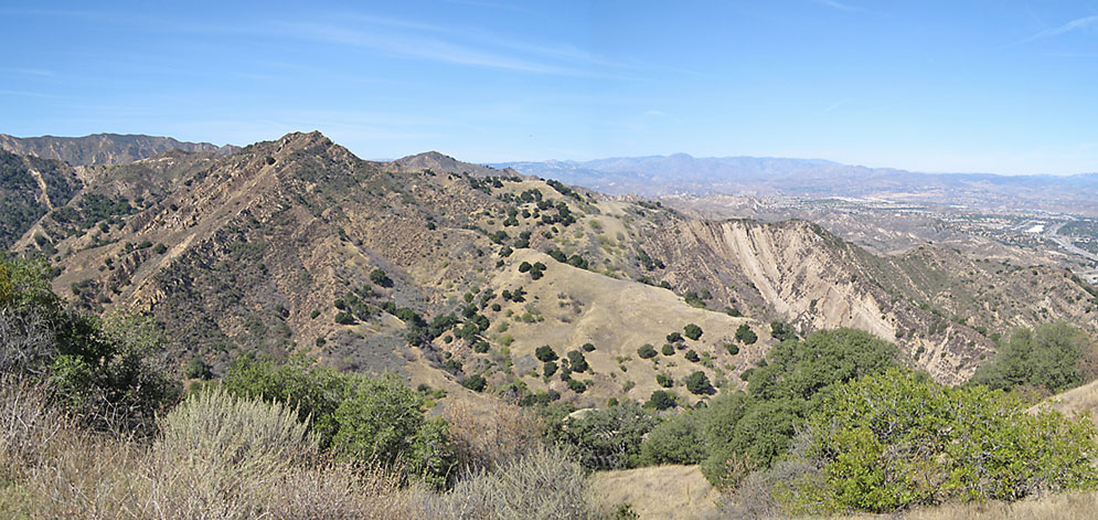
View of anticline looking west from the ridge between Rice and East Canyon just off the East Canyon road. (photo taken on 10/17/2009)
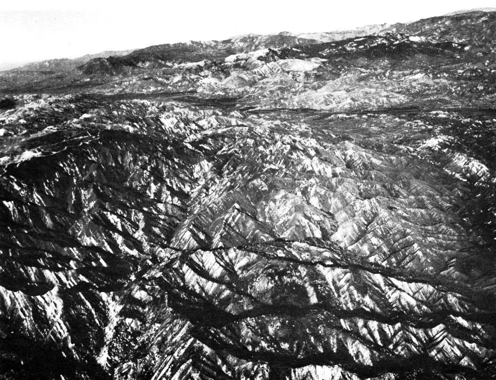
Aerial view of the Pico Anticline looking west along the axis. The Oat Mountain Syncline is also visible adjacent to the anticline on the left.
Photo taken by J.S. Shelton and R.C. Frampton. From: Higgins, J.W. (ed.), A Guide to the Geology and Oil Fields of the Los Angeles and Ventura Regions: Los Angeles: Pacific Section, American Association of Petroleum Geologists, For Annual Meeting, March 10-13, 1958.
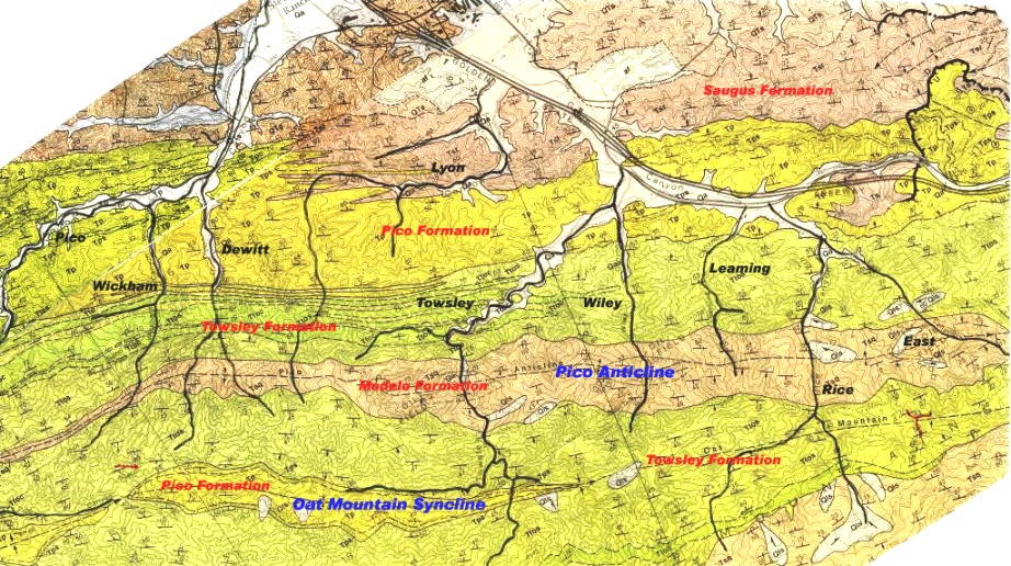
Geologic map of the canyons showing the canyon names (black), the formation names (red), and the Pico Anticline and Oat Mountain Syncline (blue). This map was created from two Dibblee maps - Oat Mountain (DF-36) and Newhall (DF-56).
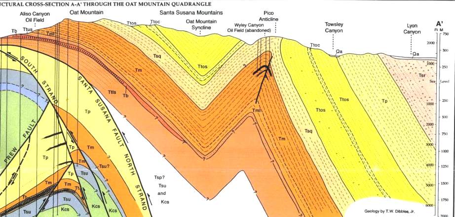
North-south cross section from Lyon Canyon to Oat Mountain. The formations are (from newer to older) Tsr-Saugus Formation, Tp-Pico Formation, Ttos,Ttoc-Towsley Formation, Tsq-Sisquoc Formation (called Modelo by almost everyone except Dibblee), Tm-Modelo Formation. From the Oat Mountain (DF-36) geologic map by Dibblee.
The Pico Anticline is the dominant geologic structure of the Newhall Oil District and runs east from Pico Canyon to East Canyon. It lies in the southern margin of the Ventura basin. The Ventura basin received sediments from the Eocene to the present, accumuating about 44,000 feet of sediments.
The structure, and how it affects the oil, was recognized early on. From "Resources of the Pacific Slope" by J. Ross Browne (San Francisco, I.H. Bancroft and Company, 1869, pp. 262-263):
Reference to the oil wells of San Fernando district, Los Angeles county, will convey a general idea of the oil formation in the Coast range.
This district is situated 30 miles northwest from Los Angeles. The formation lies in a range of mountains extending in a course nearly east and west. The central stratum is shale, which seems to contain the most oil, and inclines north and south at an acute angle, the top being from 150 to 200 feet wide, slightly depressed, and covered by a stratum of sandstone of variable thickness. This shale is bounded by a similar sandstone, alternating with thin seams of limestone and hard conglomerate. At the base of the mountains the formation is hard sand and limestone, both containing marine fossils of a recent era. These mountains reach a height of about 700 feet above the local river beds, and about 4,000 or 5,000 feet above sea level.
The oil stratum varies in width, being in some places a mile or more, as in Rice canon, in others only a few hundred feet; but is continuous for many miles. In the gulches and canons, where the water has eroded the formation and exposed the shale to the action of the atmosphere, the oil is found oozing out. The water in the district is unfit for use. Oil is also found on the summit of the mountains, which are crested with shale, being carried through the shale by capillary attraction. At some places beds of "brea," or asphaltum, have accumulated, where the oil has evaporated. The rocks, forming beds of streams which dry up during the summer, are covered with a complex alkaline efflorescence.
The manner of collecting the oil in this district is by sinking pits in the vicinity of the natural springs, in which oil and water collect. The oil is skimmed off by hand, each pit of 20 by 20 yielding about two barrels per day. When collected it is dark green in color, and about as thick as sirup in summer, and contains about 80 per cent. of oily matter, mechanically combined with 20 per cent. of water, from which it is difficult to separate it.
In other places tunnels are run into the mountain. The oil drips from the slate when it is cut through.
Four main formations are seen in the anticline. They are the Modelo (upper Miocene), Towsley (early Pliocene), Pico (middle Pliocene), and the Saugus (late Pliocene/early Pleistocene).
The Modelo Formation was deposited in a marine environment. It consists of dark gray to brownish gray shale that bleaches to light gray. It is crumbly, often has spheroidal fracturing, and sometimes contains thin layers of gypsum in fractures.
The Towsley Formation was also deposited in a marine envirnment. It consists of mostly light gray to tan sandstone, medium grained to locally gritty and pebbly. There is also some claystone and siltstone.
The Pico Formation was deposited in a shallow marine environment. It consists mainly of mostly light gray siltstone and claystone, sandstone (sometimes pebbly), and conglomerate.
The base of the Saugus Formation consist of interfingering beds of shallow water marine, brackish-water, and nonmarine deposites. The beds grade upwards into exclusively nonmarine beds. They consist of siltstone, mudstone, sandstone, and conglomerate. All have varying lithologies based on their location in the formation.
Tectonic forces created the Pico Anticline, California is divided into 11 geomorphic provinces. The anticline is in the Santa Susana Mountains which are located in the Transverse Ranges province. The Transverse Ranges consist of a series of young east-west trending structures (such as anticlines and synclines) that go against the normal northwest trending structures of the rest of California.
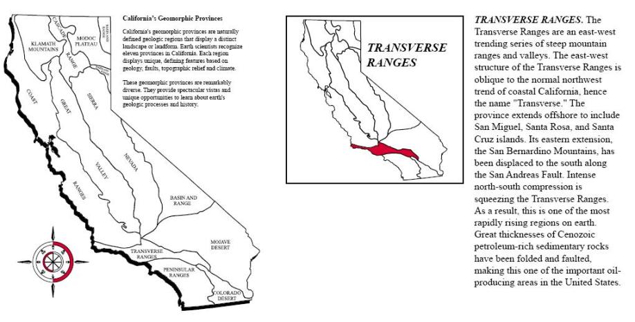
From California Geomorphic Provinces, Note 36, California Geological Survey.
The earth consists of many tectonic plates. The Pacific plate moves northwest relative to the North American plate along the San Andreas Fault. At the "Big Bend" of the fault, the Pacific Plate is compressed due to the angle of the fault changing. This compression is causing folding parallel to the fault and and thrust faults with motion perpendicular to the fault. The compression began about 2-3 million years ago. Besides creating the Pico Anticline, the compression also uplifted the San Gabriel Mountains. The Transverse geomorphic province comprises the area of the compression.
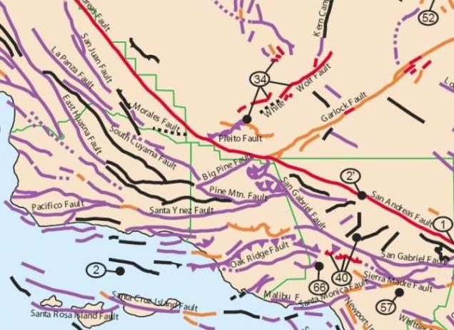
Fault map showing the Big Bend of the San Andreas Fault (in red). From the Simplifed Fault Activity Map of California by C.W. Jennings and G.J. Saucedo, 1999, California Geological Survey.
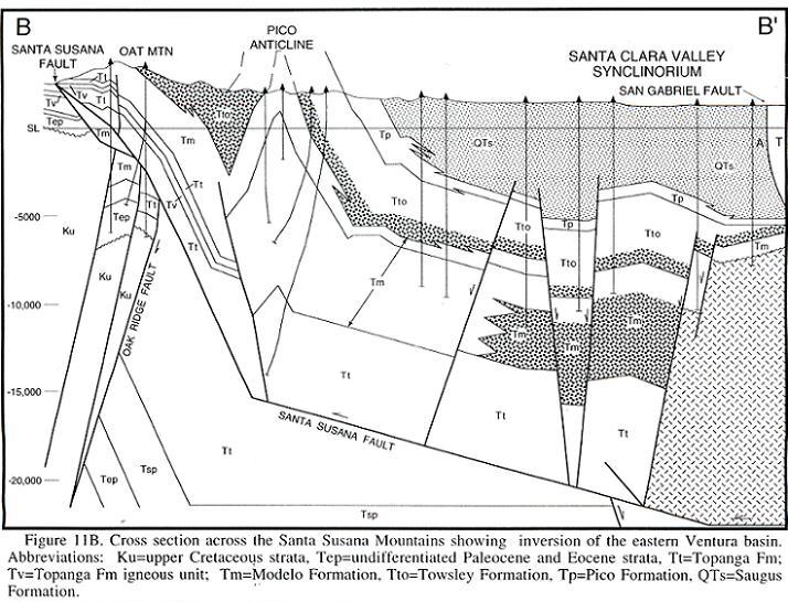
North-south cross section showing the Pico Anticline caused by compression taking place beneath the Santa Susana Mountains and the Santa Clara Valley
Figure 11B from Davis, T.L., Namson, J.S. and Gordon, S., 1996, Structure and Hydrocarbon Exploration in the Transpressive Basins of Southern California. in Abbott, P.L. and Cooper, J.D. (eds.), Field Conference Guidebook and Volume for the American Association of Petroleum Geologists, Annual Convention, San Diego, California, p. 189-238
Used by permission
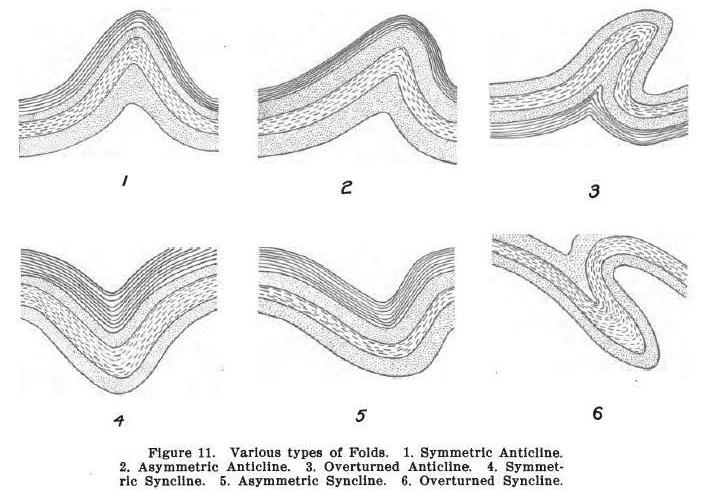
An anticline is a upward-curving fold where the oldest rock layers are in the center of the fold. The Pico Anticline extends from just west of Pico Canyon eastward to almost the San Fernando Pass, a distance of 9 miles. The dip of both sides of the anticline are almost always between 40 and 70 degrees. Some of the north flank is overturned. The anticline is parallel to a syncline on the south - the Oat Mountain Syncline.
The Pico Anticline is a tightly folded, asymetric, faulted anticline. An asymmetrical anticline is one where the cross section perpendicular to the length of the anticline is not symetrical - one of the flanks is steeper. For the Pico anticline, it is the north flank. The tops of most anticlines, including the Pico Anticline, have been eroded away. A syncline is a downward-curving fold.
From "Popular Oil Geology" by Victor Ziegler, 1918
The oil fields in all the canyons are located on the Pico Anticline. However, actual production has shown that each area is an independent accumulation with no connection to each other. The depth of the wells varies from 600 to 3000 feet. It has been stated that no two holes showed the same succession of beds and that there was no clearly defined horizon at which oil was found. The strata is lenticular and contains some faulting which made recognition of any oil-producing zone difficult. Walling (1934) did define a top, central, and lower zone, but they were based on depth.
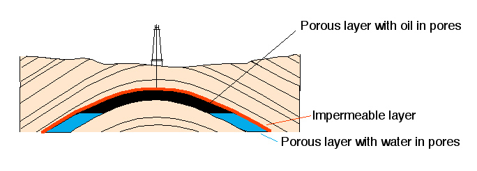
Anticlines are classic traps for petroleum. Its low density causes it to migrate upward in the fold until it is stopped by an impermeable (rocks that don't allow movement of fluids) barrier such as an especially dense layer of shale, limestone, or sandstone. Faults can also act as traps.

Surface Geologic Map of Newhall Oil Field. From "California Oil and Gas Fields, Vol II, Southern, Central Coastal, and Offshore California", Division of Oil & Gas, Pub. No. TR 12, Sacramento, Third Edition 1991, p. 306. Larger version here.