Dry Canyon in the Los Angeles Aqueduct Reports
The following Dry Canyon updates were taken from the Annual Reports and the Final Report of the Bureau of the Los Angeles Aqueduct of the City of Los Angeles Department of Public Works to the Board of Public Works. These reports are available for download from the internet from Google books. Also, SharingHistory.com sells excellant scans of the 1916 Final Report and the 1913 Pictorial History on one CD at a very low price.
First Annual Report (March 15th, 1907)
(p. 39) "A small regulating reservoir will be constructed in the San Francisquito Canyon at this proposed point of lower diversion sufficient to regulate the hourly fluctuation from the power house."
(p. 122) "From the Fairmont Reservoir [in the Antelope Valley] it is proposed to pierce the main mountain range with the longest tunnel on the line, 25,000 feet in length, passing under Elizabeth Lake Valley between the upper and lower lakes, at a depth of 350 feet below the valley floor. The tunnel is projected to leave the Fairmont Reservoir at a depth of 75 feet below the water line, and be built as a pressure tunnel for subsequent power development.
It will emerge into San Francisquito Canyon, down which the water is to be permitted to flow a distance of about eleven miles, with a total fall of 1550 feet from the water line level of the Fairmont Reservoir, until such time as the power available from this drop is utilized and the water conveyed through conduits required to develop the power.
Picking up the water at an elevation of 1470 feet, by means of a diverting dam in San Francisquito Canyon at the lowest narrows, the delivery to the head of the San Fernando Valley will be effected in a distance of 15.18 miles." No mention of Dry Canyon yet.
Third Annual Report (November 30th, 1908)
(p. 16) "From the tail race of the second power house [in San Francisquito Canyon] the conduit leading to Dry Canyon Reservoir is 14,400 feet in length and will have a capacity of 1,000 second feet. The capacity of Dry Canyon Reservoir is 1325 acre feet with a dam 55 feet in height. The province of this reservoir is to regulate back to a normal flow the fluctuating discharges through the power plants so as to reduce the size of the Aqueduct below."
(pp. 74-75) "Below the power sites, in order to reduce construction costs, it is desirable to regulate the flow back to its normal of 400 second feet. This may be accomplished with the Dry Canyon Reservoir which is 14,400 feet from the lower drop in the San Francisquito Canyon. This site being off the main drainage line of the San Francisquito, and in a small valley with little drainage, is free from serious danger of silting. The point of delivery to the Dry Canyon Reservoir will be at an elevation of 1505 feet, and the grade elevation at the outlet from it will be 1500 feet, the storage capacity between these levels being about 300 acre feet. The dam will be approximately 510 feet long on top and 60 feet high and will contain about 150,000 cubic yards of earth. It is proposed to construct this dam by the hydraulic fill process, which at a cost of twenty cents per cubic yard will be $30,000. The length of the reservoir will be 4,100 feet and its use will effect a saving in cost of conduit, besides serving the purpose for with it is designed."
Actual work on the aqueduct was not started until October 1, 1908. The above was just the plan at that time. A "second foot" is the volume of water represented by a flow of 1 cubic foot per second for 24 hours. The plan called for the Dry Canyon dam to accept up to 1,000 second feet but only discharge 400 second feet. Besides regulating the flow out, it would also save money because the diameter of the aqueduct could be smaller.
Fourth Annual Report (July 1, 1909)
(p. 19) "Work on this division (Saugus Division - No. 11) was begun in October, 1908, and has been actively prosecuted." No mention of the Dry Canyon Dam or Reservoir.
Fifth Annual Report (July 1, 1910)
(p. 16) "Good progress is being made on the excavation of the core-wall trench for the Dry Canyon dam. This dam, situated at the end of the power tunnels, will create a small reservoir of 1,325 acre feet capacity to be used only for flow regulation. Soundings have demonstrated the presence of bedrock at an average depth of 75 feet. It is proposed to excavate this trench to bedrock if possible, and if not, to within 15 feet of the required depth, and drive sheet piling to a firm foundation. The trench, 6 feet in width, will then be filled with concrete to the ground surface. Estimates for the dam, exclusive of core wall construction, call for the moving of 164,000 cubic yards of earth, which will be deposited in place by the hydraulic process."
Sixth Annual Report (July 1911)
(p. 43) "As stated above, in the description of the Elizabeth Tunnel, the capacity of the Aqueduct will be sufficient to carry a peak flow of water of 1,000 second feet through the power conduits. This large flow has to be cared for as far south as the Dry Canyon Reservoir on the Saugus Division, where it is regulated back to a uniform flow of 400 second feet out of this basin. South of the Dry Canyon Reservoir, the conduit has been constructed with a capacity of 400 second feet."
(p. 43) "In the latter part of May, 1910, all work on the Saugus Division was suspended, except the Dry Canyon Dam and the lining of Tunnel No. 104, in accordance with orders of the Board of Public Works to meet the financial stringency then existing. As more funds became available, the volume of work was increased on this division until normal conditions were restored in the fall of 1910."
(p. 45) "At the Dry Canyon Dam the core-wall trench has been excavated and filled with clay, and about 60 percent of the earth fill of the dam has been placed. The excavation of the core wall trench for Dry Canyon Dam was an interesting and difficult piece of work. The trench has an average depth of 75 feet, one-half of which was water-bearing sand and gravel. A shaft was sunk in the rock on the east abutment to the level of the lowest bed-rock in the center of the canyon, from the bottom of which a drift was run along the axis of the dam in the bed-rock to the water-bearing gravel. At the end of the drift, perforated two-inch pipes were driven diagonally up through the water area, and the flow was handled with a five-inch centrifugal pump. The trench excavation was then extended down as the water plane receded. A stream shovel outfit has been installed near the Dry Canyon dam site, dump wagons are loaded by the shovel and material is deposited at the upper and lower toes of the dam. Water has been diverted through the finished Aqueduct from the San Francisquito Creek to the dam site, and a pond established against the upper toe of the dam. A pumping plant has been installed and the water conveyed through pipes and jets to a clay bank which is knocked down ad dissolved by the jet. The muddy water is then run in a flume to a second pump where it is picked up and carried to the basin between the two toes of the dam. The discharge pipes are so arranged that the water is delivered at the extreme outer edges of this pool, the coarser materials being deposited on the outside and the finer and impervious materials conveyed to the central axis of the dam connecting with the core wall in the trench. A tight dam is being obtained in this manner."
Seventh Annual Report (July 1912)
(pp. 35-36) "The Dry Canyon Dam on the Saugus Division is 528 feet long, has a center height of 61 feet and contains 140,000 cubic yards of earth. The outer toes of the dam have been progressively carried up by earth placed by wagons which were filled by a steam shovel. The central portion of the dam was pumped in position by the hydraulic method. The Dry Canyon Reservoir has a storage capacity of 1,325 acre feet and its province is to regulate back to uniformity the irregular flow that may be discharged through the power plants. This dam is finished."
Final Report on Construction (1916)
(p. 22) "The Dry Canyon reservoir on the Saugus division, located a short distance below the lower of the San Francisquito power plants, has a storage capacity of 1,325 acre feet and its province is to regulate back to uniformity the irregular flow that may be discharged through the power plants."
(p. 76) "The Dry Canyon reservoir is located at the south end of the 1,000 second-foot tunnels in the Saugus Division. This reservoir has a capacity of 1,325 acre feet, with a dam 61 feet in height. The elevation of the high water will be 1,505 feet and the area of the water surface 61 acres."
The main section on the reservoir and dam in the complete report is as follows (pp. 128-141):
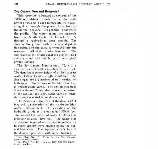
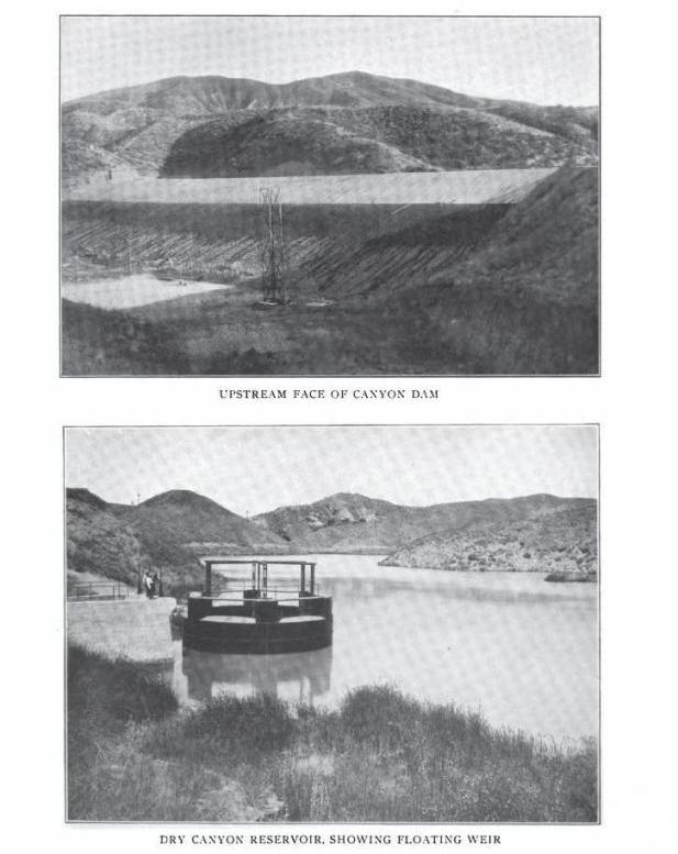
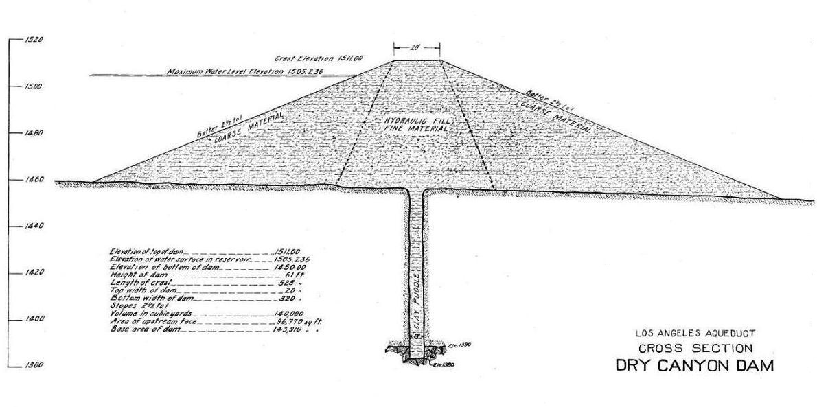
Plate 18 from the final report. This is the horizontal cross section of the dam. See how it changed in 1953 on the main page with the Keightley cross section diagram.
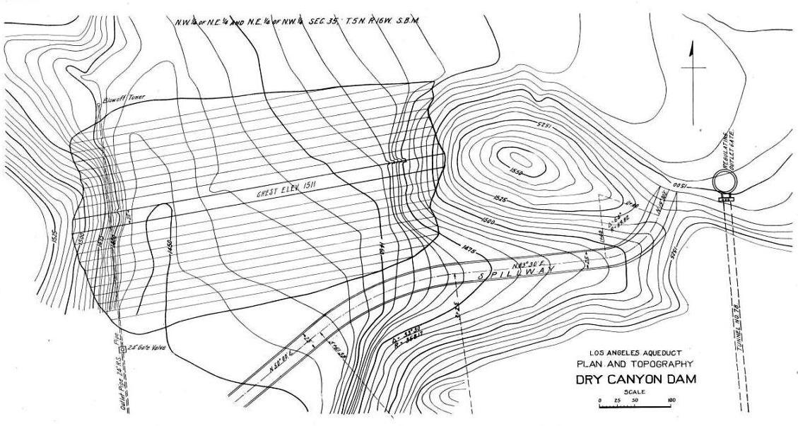
Plate 19 from the final report. This is looking down on the dam from above.
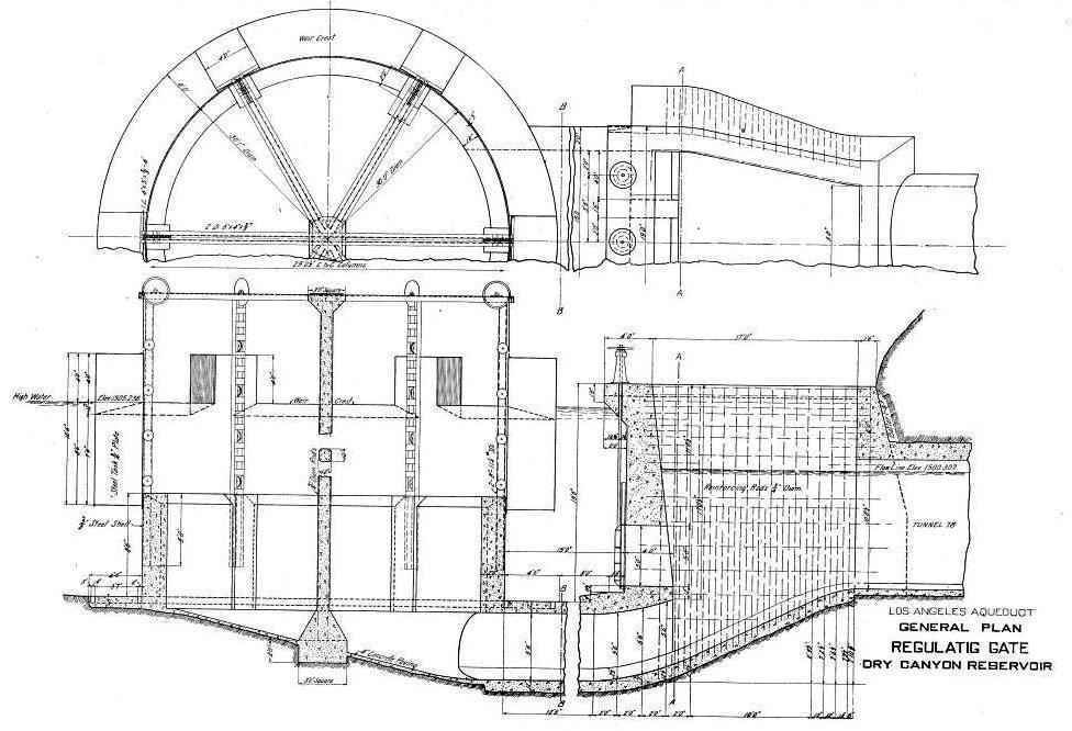
Plate 20 from the final report. This is the plan of the original regulator, which was replaced in 1941.
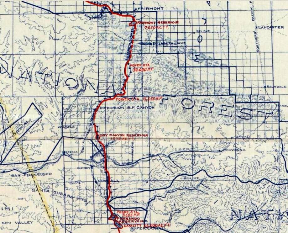
Los Angeles aqueduct map between the Antelope Valley and the San Fernando Valley. Dry Canyon reservoir is in the lower middle of the map.
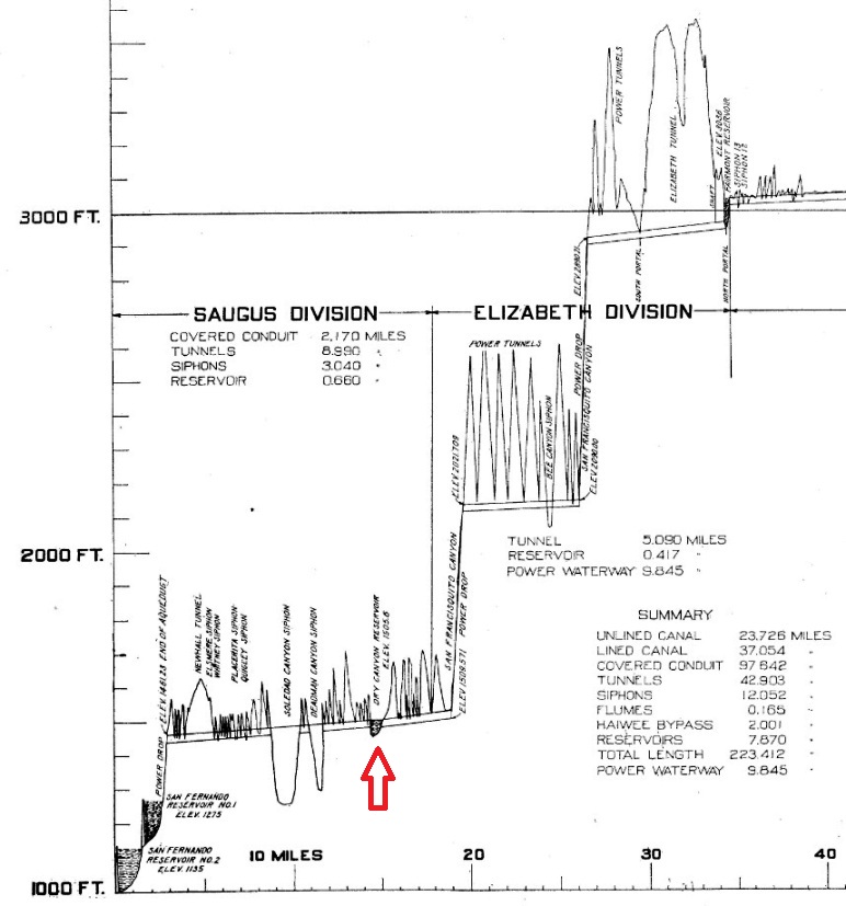
Aqueduct elevation profile from Plate 4 of the final report. Dry Canyon Reservoir is above the red pointer. Notice the dramatic 2000-foot drop in elevation in 35 miles from the Fairmont Reservoir in the Elizabeth Division to the San Fernando Reservoir in the Saugus Division. The Summary is for the entire aqueduct, not just these two divisions.
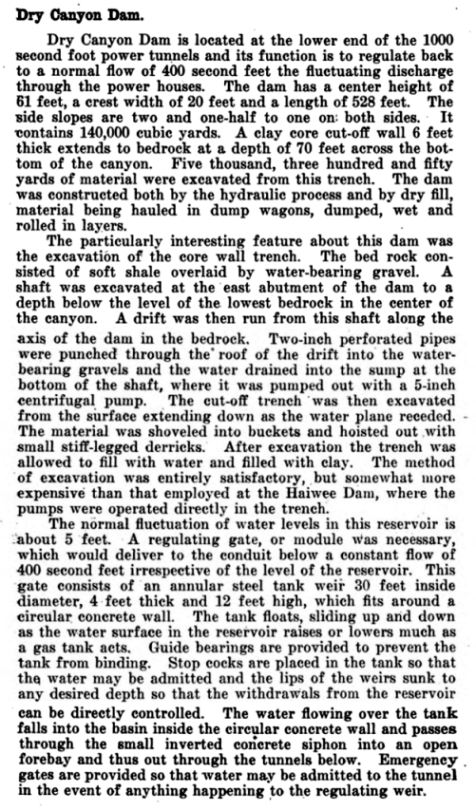
From the Monthly Journal, Utah Society of Engineers, Volume Three, No. 4, April, 1917, "Los Angeles Aqueduct" by J. B. Lippincott, pp. 104-106.