Placerita Canyon - Resources for Oil and Geology
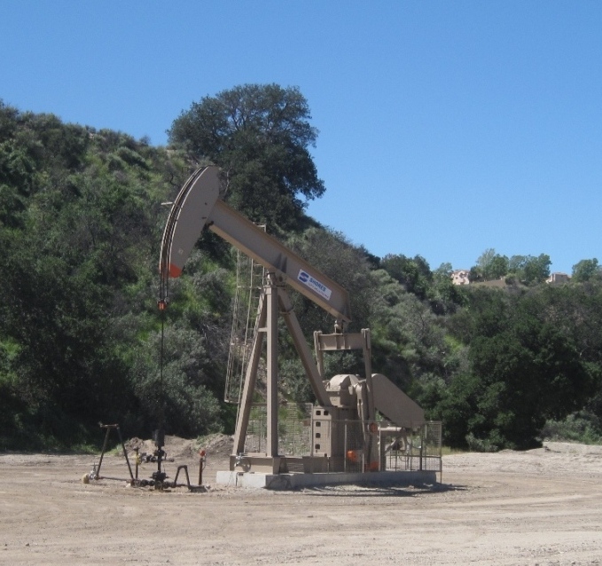
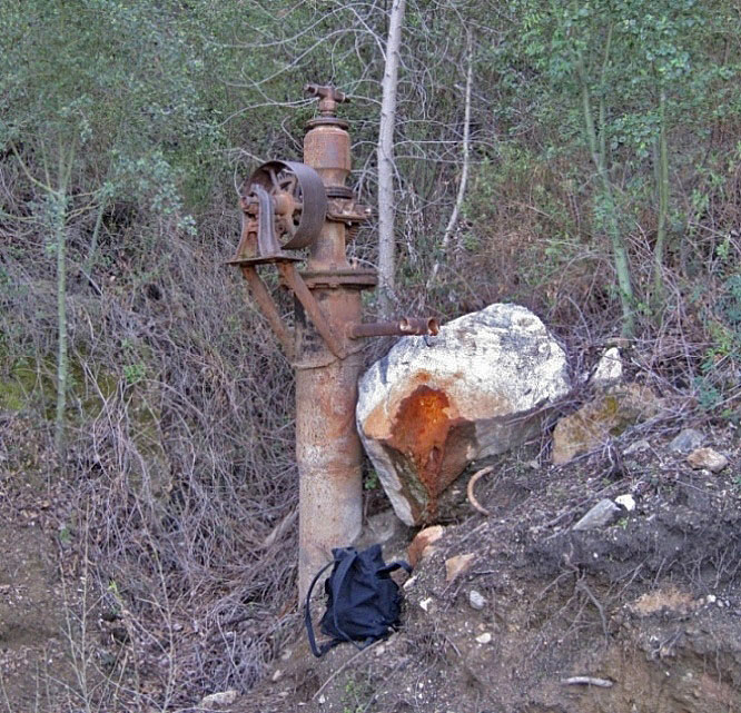
Placerita Canyon not only still contains a working oil field but also evidence of drilling back to the early 1900's
..........OIL HISTORY BRIEF SUMMARY..........
CalGEM (name changed from the California Division of Oil, Gas, and Geothermal Resources in 2020) records show that over 1000 wells have been drilled in Placerita Canyon. Most of these wells were drilled west of Sierra Highway.
The earliest documented oil well was described on page 355 of the 12th Report of the State Mineralogist, Two Years Ending September 15, 1894. It's location is not known:
"San Bernardino Oil Well - This is in Placerita Canyon, 4 miles from Newhall. This well is 640 feet deep; a set of tools was lost in it."
The "Schist area" or "White Oil field" was discovered in 1896 when two gold miners, George W. Freeman and Frank Nelson, were digging a shaft in the crystalline rocks. Instead of gold, they found a white, nearly pure, oil seeping into their shaft. This created quite a sensation and ten wells were drilled by 1905, including three by the Freeman & Nelson White Oil Company and four by the New Century Oil Company. However, none of them found oil in commercial quantities. These wells were drilled in and around the Nature Center property, most west of Los Pinetos canyon, but some east of it. Here is a Microsoft Excel list of the white oil field wells that I have compiled from Walling (1934) and DOGGR records.
Another small group of wells were drilled between 1920 and 1938 starting with Equity Oil Company's "Daisy" 1 well (later called York 1). These wells had a limited success and in April of 1935, average well production was only about 9 barrels a day.
In March of 1948, the Nelson-Phillips Oil Company drilled well "Kraft" 1. It had an initial production of 100 barrels of oil per day of 16 degree API oil, which encouraged new activity in the Placerita Canyon. This area was named the Kraft-York Area. In January of 1949, Milfred Yant and Ramon Somavia drilled well "Juanita" 1 about one mile north of the Kraft-York area. This well had an initial production of 340 barrels per day of 22 degree API oil. This area became the Juanita Area. A major increase of leasing and drilling began. The State Well Spacing Act was declared unconstitutional leading to unrestricted drilling. The Juanita Area became known as "Confusion Hill" (see Confusion Hill webpage).
In July of 1949, the area was named the Placerita Oil Field by the Division of Oil and Gas (DOG).
With so many wells being drilled, production steadily declined after 1950. In 1954 a water flooding (injection) program was started by the Crown Central Petroleum Corp. In 1964, steam injection was tried and proved successful. Today, the Placerita Oil Field is still producing thanks to EOR (enhanced oil recovery) methods.
Crown Central Petroleum Corp. sold out to Tenneco Oil Co. on December 10, 1985, but it is hard to tell if Crown owned all the leases on the Placerita field or whether Tenneco bought out all the companies with leases, consolidating the field under one lease owner. On March 21, 1989, Arco Oil & Gas Co. purchased the field from Tenneco. In 1995, they became Arco Western Energy. In 1998, the name was changed to Aero Energy LLC.
On February 12, 1999, Berry Petroleum Company purchased the Placerita oilfield from Aera Energy LLC for $35 million. At that time the property comprised 8 leases totaling about 700 acres. Production was about 2,800 net barrels per day of 13 degree gravity crude oil from 120 producing wells and 56 continuous steam injection wells. The acquisition also included a 42 megawatt cogeneration facility which generated electricity sold to a major utility and which provided about 13,500 barrels of steam per day for injection in the oilfield.
In December of 2013, LinnCo LLC, a subsidiary of LINN Energy LLC, merged with Berry Petroleum Company by acquiring all of Berry's outstanding stock for $4.3 billion. This also included the assumption of Berry's debt. Berry thus became an indirectly wholly-owned subsidiary of LINN Energy. The new company name became Berry Petroleum Company LLC.
In May of 2016, LINN Energy LLC, with $8.3 billion of debt, filed for bankruptcy under Chapter 11. In February of 2017, as part of the bankruptcy reorganization of Linn, Berry Petroleum Company LLC emerged as a separate stand-alone company, sole owner of the Placerita Oil Field.
In February of 2020, Berry Petroleum Company changed their name to Berry Corporation.
In October of 2021, the Berry Corporation sold all its Placerita holdings to Shadow Wolf Energy LLC (California). This company was incorporated on May 22, 2021, and has a registered address of 25121 N. Sierra Highway, Santa Clarita, the address of the Placerita oil field. The company is a branch of Shadow Wolf Energy LLC (Nevada), which was incorporated on May 12, 2021. There is also a Shadow Wolf Energy Placerita LLC, incorporated on October 21, 2021, the date that the Placerita oil field was bought. Its address is in Beverly Hills. Seems like the companies were created just to buy the Placerita oil field.
..........WEB PAGES..........
The Story of Confusion Hill (aka Mad Mountain) - short version
Historic photos - Oil Related (including Confusion Hill)
Historic photos - Non-oil related
Recent photos - including oil field artifacts
Geology resources and photos
1842 Gold Discovery Site (with historical photos)
First Oak of the Golden Dream plaque (with historical photos)
Current oil wells near roads
Abandonment of Oil Wells in San Gabriel Fault Zone - May 2022-May 2023
Life of Milfred R. Yant - Before and after Confusion Hill
..........WEBSITES..........
Placerita Canyon page on the Santa Clarita Valley History Website
Placerita Canyon Nature Center website
..........CalGEM..........
CalGEM (old DOGGR - name changed in 2020)
Placerita Field map (PDF) indicating all known Placerita Canyon well locations (map 251).
Microsoft Excel file listing all known Placerita Canyon wells.
..........DOCUMENTS, MAPS, NEWSPAPER ARTICLES, AND SNIPPETS (in date order)..........
1875: Map of Township No. 3 North, Range No. 15 West, San Bernardino Meridian, dated January 14, 1875, U.S. Department of the Interior, Bureau of Land Management, General Land Office Records (PDF 10.3MB).
1897: Map of the Los Angeles County Public Lands: T. 3-4 N. R. 15 W. S.B.M., circa 1897, from the Huntington Museum. Complete map here.
1897: Discovery of white oil in 1896 from the San Francisco Chronicle of February 3, 1897.
1900: Snippet from Petroleum in California, Lionel Redpath, 1900, p. 49.
1900: The Pioneer White Oil Company from the Los Angeles Saturday Post of September 1, 1900.
1900: In Placerita Canyon from the Los Angeles Herald of November 16, 1900.
1900: The White Oil of Placerita from the Pacific Oil Reporter of November 16, 1900.
1900: New Century Oil Company from the Los Angeles Herald of December 12, 1900.
1900: White Oil Wells from the Los Angeles Herald of December 12, 1900.
1901: Placerita's Natural Gas from the Los Angeles Times of January 12, 1901.
1901: Placerita White Oil from the Los Angeles Times of January 24, 1901.
1907: Snippet from The Santa Clara Valley, Puente Hills and Los Angeles Oil Districts Southern California, G.H. Eldridge and R. Arnold, USGS Bulletin No. 309, pp. 100-101.
1913: Snippet from Petroleum in Southern California, Paul Prutzman, California State Mining Bureau Bulletin 63, pp. 177-178.
1913: Map of the Newhall Oil Field from Petroleum in Southern California, Paul Prutzman, California State Mining Bureau Bulletin 63.
1919: Pacific Fields Wonders from Petroleum Age, November 1919, Vol. 6, No. 11, p. 480.
1924: Snippet from Geology and Oil Resources of a Part of Los Angeles and Ventura Counties, California, William S. W. Kew, USGS Bulletin 753, pp. 155-156.
1932: Occurrence of Oil in Metamorphic Rocks of San Gabriel Mountains, Los Angeles County, California, Arthur B. Brown and W. S. W. Kew, Bulletin of the AAPG Vol. 16, No. 8, pp. 777-785 (PDF 1.3MB).
1934: Placerita Canyon Area from Report on Newhall Oil Field, R.W. Walling, Vol. 20 No. 2, Summary of Operations California Oil Fields, Division of Oil and Gas (PDF .2MB).
1948: Snippet from the Mineral Information Service, Division of Mines, Department of Natural Resources, State of California, November, 1948, p. 3.
1949: Snippet from the Mineral Information Service, Division of Mines, Department of Natural Resources, State of California, January, 1949, p. 4.
1949: Oil Prospects Upper Placerita Canyon Area, Hampton Smith (PDF 7.9MB).
1949: Placerita Oil Field, Cecil L. Barton and Norman N. Sampson, Summary of Operations-California Oil Fields, Vol. 35, No. 2, pp. 5-14 (PDF 1.1MB).
1949: Second Oil Gusher Sets Newhall Agog from the Los Angeles Times of March 3, 1949.
1949: Oil Men Feud in Newhall Field from the Oxnard Press Courier of October 27, 1949.
1949: Newhall-Placerita from the Bakersfield California of October 29, 1949.
1949: Wildcat Battle Halted as Oil Drills Rotate from the Bakersfield California of October 31, 1949.
1949: Frenzy Grips Placerita Canyon from the Daily News of 1949 (unknown day).
1950: Placerita Oil Field, Robin Willis, (PDF 4.5MB).
1952: Placerita Oil Field, Robin Willis, AAPG SEPM SEG Guidebook, Joint Annual Meeting, Los Angeles, California, (similar to Willis' 1950 document) (PDF 1.5MB).
1958: Placerita Oil Field, pp. 119-120 from Geology and Mineral Deposits of San Fernando Quadrangle, Los Angeles County, California, Gordon Oakeshott, Division of Mines Bulletin 172.
1958: Map of the Placerita Oil Field, Plate 5 from Geology and Mineral Deposits of San Fernando Quadrangle, Los Angeles County, California, Gordon Oakeshott, Division of Mines Bulletin 172 (PDF .1MB).
1961: Water Flood Adds Millions of Barrels of Potential Oil Reserves, Los Angeles Times, January 4, 1961.
1961: Snippet from California Oil and Gas Fields Maps and Data Sheets, Part 2, Los Angeles-Ventura Basins and Central Coastal Regions, Division of Oil and Gas, pp. 632-633 (PDF .6MB).
1962: Placerita Oil Field from Geology of Southeastern Ventura Basin Los Angeles County California, E.L. Winterer and D.L. Durham, Geological Survey Professional Paper 334-H, pp. 74-75.
1962: Recent Developments in the Kraft-York Area of Placerita Oil Field, Richard B. Tudor, Summary of Operations-California Oil Fields, Vol. 48, No. 1, pp. 47-53 (PDF 1.1MB).
1974: Geologic Report: Oil Possibilities in the Vicinity of Placerita Canyon County Park, Los Angeles County, Engineering Geology Section, Design Division, Department of County Engineer, Allan E. Seward, on SCV History website.
1983: Open Cycle Cogeneration Project - Placerita Field, Doscher, El-Arabi, and Stiglic, Society of Petroleum Engineers (PDF .3MB).
1983: Placerita Field, Los Angeles County, California, from An Evaluation of Heavy Oil Mining, Final Report, Volume I, by Piper, Riddell, and Trent, pp. 153-163 (PDF 2.5MB).
1994: Placerita Oilfield - A Case Study of Steamflooding a Complexly Stratified Reservoir, Thomas A. Berkman from Pacific Petroleum Geologist Newsletter of the Pacific Section American Association of Petroleum Geologists, Fall 1994 No. 4.
1996: Summary of Placerita Oil Field, Tom Berkman, From Structure and Hydrocarbon Exploration in the Transpressive Basins of Southern California, pp. 200-203 (PDF 5.5MB).
2004: 2004 Berry Petroleum Company Management Powerpoint Presentation.
2008: 2008 Berry Petroleum Company Investor Conference (PDF 5.5MB).
2010: Oil Wells and Equipment, Don Kott, Unpublished Docent Report, Placerita Canyon Nature Center (PDF 10.3MB).
2011: South Placerita Oil Field - Re-Activation Project, Amrich Energy Inc (PDF 1.9MB).
2012: 2012 Berry Petroleum Company Presentation (PDF 3.5MB).
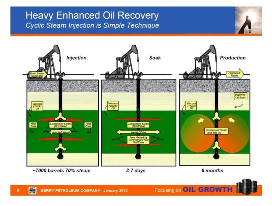
Steam injection is an increasingly common method of extracting heavy crude oil and is common in the Placerita oil field. Placerita oil typically has an API gravity of less than 21 degrees, which is quite heavy. Steam injection is an enhanced oil recovery (EOR) method and is by far the most energy-intensive and water-intensive method used in California oil extraction. There are several different forms of the technology, with the two main ones being Cyclic Steam Stimulation (CSS) and Steam Flooding. Both are commonly applied to oil reservoirs which are relatively shallow and which contain crude oils which are very viscous at the temperature of the native underground formation. Berry (owned by Linn) is using both EOR methods in the Placerita Oil Field.
The above diagram shows one well during the 3 phases of CSS. Steam is injected into a well ("huff" phase) introducing heat. Then the well is shut-in allowing the dissipating heat to thin the oil (the "soak" phase). Finally, the well is placed back on production - i.e. pumped (the "puff" phase). The CSS process can be repeated until production falls below a profitable level. (The above schematic diagram is from the 2012 Berry presentation.)
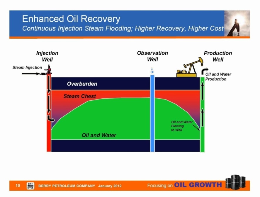
In steam flooding, some wells are used as steam injection wells and other wells are used for oil production. Two mechanisms are at work to improve the amount of oil recovered. The first is to heat the oil to higher temperatures and to thereby decrease its viscosity so that it more easily flows through the formation toward the producing wells. The second mechanism is the physical displacement in a manner similar to water flooding (an EOR method used here in the past), in which oil is meant to be pushed to the production wells. While more steam is needed for this method than for the cyclic method, it is typically more effective at recovering a larger portion of the oil. (The above schematic diagram is also from the 2012 Berry presentation.)
Berry Company logos through the years (oldest on left)
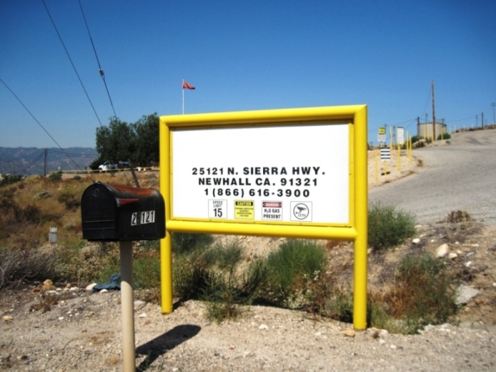
Berry Corporation has been covered over on all signs after sale of the Placerita Oil Field to Shadow Wolf Energy LLC in October of 2021. This new company doesn't have a corporate logo yet on almost all of the signs around the field.
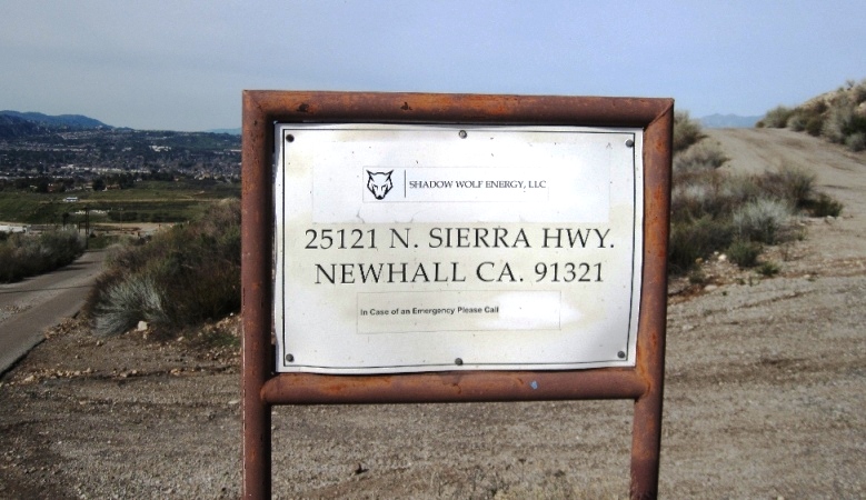
In February of 2023, I did find this remote sign with a small Shadow Wolf sticker.
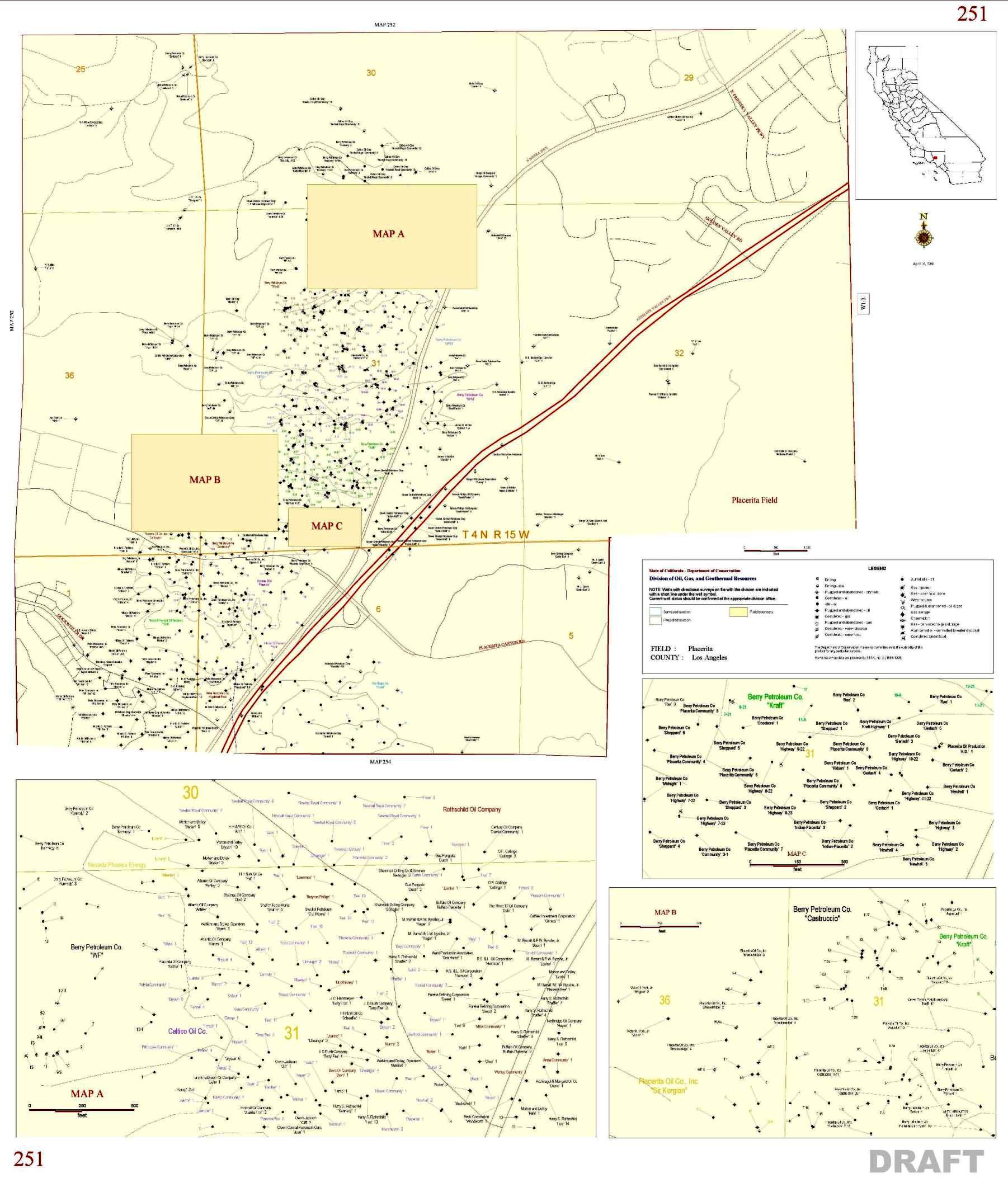
To say that a lot of wells were drilled in the Placerita Oil Field is an understatement. This is Map 251 from the Division of Oil, Gas, and Geothermal Resources (DOGGR) from 2002. A larger and clearer PDF version can be seen here. DOGGR is now known as CalGem (the California Geologic Energy Management Division).