| Date of Claim | Locators | Name of Claim | Book-Page | Used on Patent |
|---|---|---|---|---|
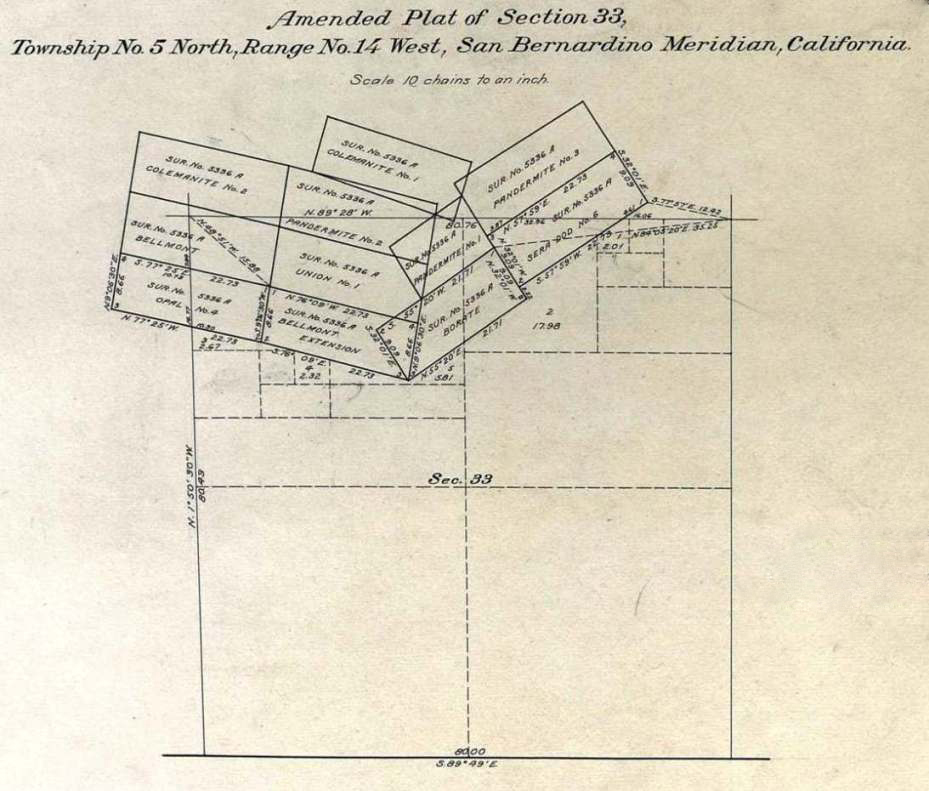
| 7/1/1907 | Ebinger & Shepard | Bellflower | 30-162 | Y |
| 8/16/1907 | Ebinger & Shepard | Bellmont | 29-261 | Y | 8/24/1907 | Blumenberg, Ebinger, Shepard | Bellflower Extension | 28-270 | Y |
| 8/26/1907 | Blumenberg, Ebinger, Shepard | Bellmont Extension | 28-271 | Y |
| 8/27/1907 | Blumenberg, Ebinger, Shepard | Borate | 28-273 | Y |
| 8/29/1907 | Blumenberg, Ebinger, Shepard | Pandermite No. 1 | 28-275 | Y |
| 8/29/1907 | Blumenberg, Ebinger, Shepard | Pandermite No. 2 | 28-272 | Y |
| 9/8/1907 | Blumenberg, Ebinger, Shepard | Pandermite No. 3 | 30-187 | Y |
| 9/8/1907 | Blumenberg, Ebinger, Shepard | Colemanite No. 1 | 30-188 | Y |
| 1907 | Blumenberg, Ebinger, Shepard | Colemanite No. 2 | not found | Y |
| 9/9/1907 | Thorkildsen | Sera Dod | SFPMD K-124 | Y |
| 9/9/1907 | Thorkildsen | Sera Dod Borate | 29-273 | |
| 9/13/1907 | Blumenberg, Ebinger, Shepard | Pandermite No. 4 | 28-283 | Y |
| 9/13/1907 | Thorkildsen | Sera Dod No. 1 | 29-275 | Y |
| 9/13/1907 | Thorkildsen | Sera Dod No. 2 | 30-178 | Y |
| 9/21/1907 | Thorkildsen | Sera Dod No. 3 | 30-182 | |
| 9/21/1907 | Thorkildsen | Sera Dod No. 4 | 30-180 | Y |
| 9/21/1907 | Thorkildsen | Sera Dod No. 5 | 30-181 | Y |
| 9/21/1907 | Thorkildsen | Sera Dod No. 6 | 30-180 | Y |
| 9/24/1907 | Blumenberg, Ebinger, Shepard | Opal No. 1 | 29-278 | |
| 9/24/1907 | Blumenberg, Ebinger, Shepard | Opal No. 2 | 28-282 | |
| 9/24/1907 | Blumenberg, Ebinger, Shepard | Redrock | 30-185 | Y |
| 9/24/1907 | Blumenberg, Ebinger, Shepard | Redrock Extension | 30-186 | Y |
| 10/14/1907 | Blumenberg, Ebinger, Shepard | Opal No. 3 | 29-282 | |
| 10/14/1907 | Blumenberg, Ebinger, Shepard | Opal No. 4 | 28-289 | Y |
| 6/26/1908 | Blumenberg | Union No. 1 | 34-135 | Y |
| 6/26/1908 | Blumenberg | Union No. 2 | 33-137 | |
| 4/19/1916 | Sterling Borax Co. | Bellflower Mill Site | 46-260 | Y |