The Old Road
The Old Road (El Camino Viejo - the old road) started in San Pedro and eventually reached San Francisco. (See map at bottom of page.) In the Newhall Pass area, it probably originated as an Indian trail. As more white men passed over it, the trail became a (very poor) road.
There are many accounts (see Ripley) of travelers on the road through the pass (Cuesta Viejo - old grade). One of the first was by Fray Juan Crespi who was on Portola's expedition of 1769. He wrote "...ascended a sharp ridge to a high pass, the ascent and descent of which was painful, the descent being made on foot because of the steepness". This kind of description of going through the pass (a steep ascent followed by a steep descent) was common.
From the "Report of Lieutenant R. S. Williamson, Corps of Topographical Engineers, Upon the Routes in California to Connect with the Routes near the Thirty-fifth and Thirty-second Parallels" from Volume 5 of the "Reports of Explorations and Surveys to Ascertain the Most Practicable and Economical Route for a Railroad, Mississippi River to the Pacific Ocean", 1853-4 (p.35):
Two small streams, rising near the crest of the Susannah range, and one-quarter of a mile apart, flow in opposite directions - the one north into the Santa Clara, the other south towards the mission of San Fernando. Between the two is a sharp crest, where the inclination is over 1,000 feet to the mile. This is the nature of this pass, which is only 8 3/4 miles from base to base.
From "Saga of Rancho El Tejon" by Frank Latta (see sources), Jose Jesus Lopez (he lived at his father's Lopez Station starting in 1860 at age 8 and became the manager of Beale's sheep and cattle holdings on the Rancho El Tejon in 1874 and knew Beale well) recounts:
[p.65] It should not be mistaken that this road [the Old Road] was established for the use of the stages that carried the Overland Mail. It had been in use more than sixty years before the first Overland Stage passed over it. My father freighted with ox teams and carretas over the old road as early as 1845 and his grandfather, Claudio Lopez, had gone over the route with ox carts and established that road as early as 1780.
[p.197] Before the cut [Beale's Cut] was made, all travel, including the stages, went around the hill near where the cut is now, and over a grade much steeper than the one in the cut.
Don Antonio del Valle used to take ox carts over a much steeper hill just south and east of present Newhall. It seems almost impassable of ox carts, but Don antonio himself told me that two yoke of oxen used to pull an empty carreta to the top of the hill, going directly up the west side.
By the 1850's, something had to be done to make it easier for larger wagons to get through.
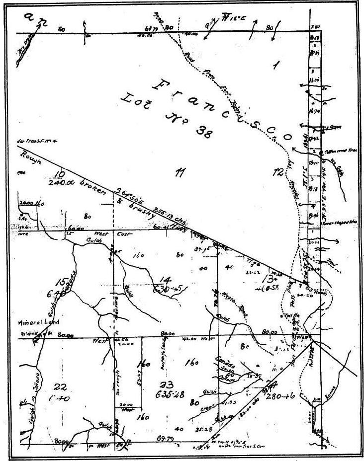
Old map of the whole area from Ripley. The large area (lot No 38) is the southeast corner of Rancho San Francisco. The map is dated 1853-1875. A PDF version is available here.
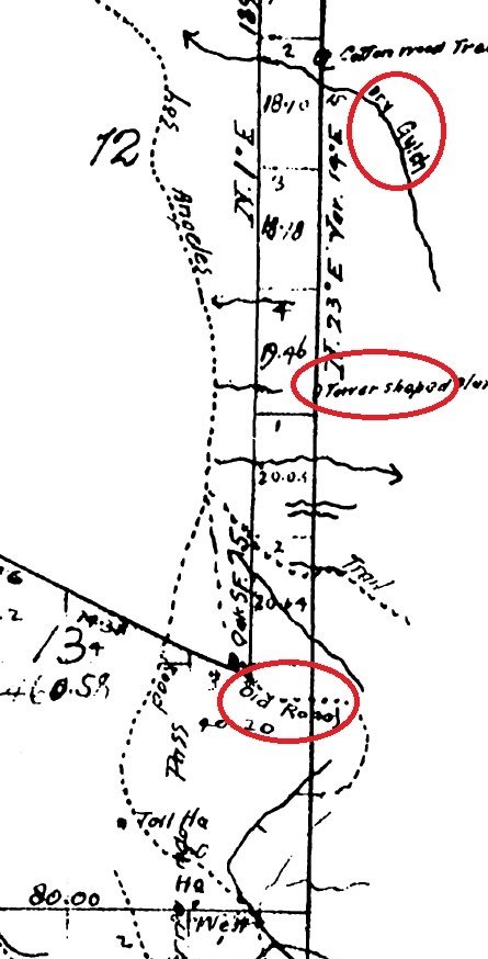
A close-up of the map showing the Old Road running through the Tunnel area. The dry gulch is Elsmere Canyon. The tower shaped bluff is shown on many of the photos of the area and shows that the Old Road both parallels and, in some places, runs under Highway 14 (and certainly not in Elsmere Canyon as some, mainly Jerry Reynolds, have claimed - see La Puerta page on the Elsmere Canyon webpage).
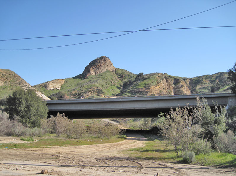
The "tower shaped bluff". Looking east at the Los Pinetos undercrossing of Highway 14. (Photo taken on 2/13/2010)
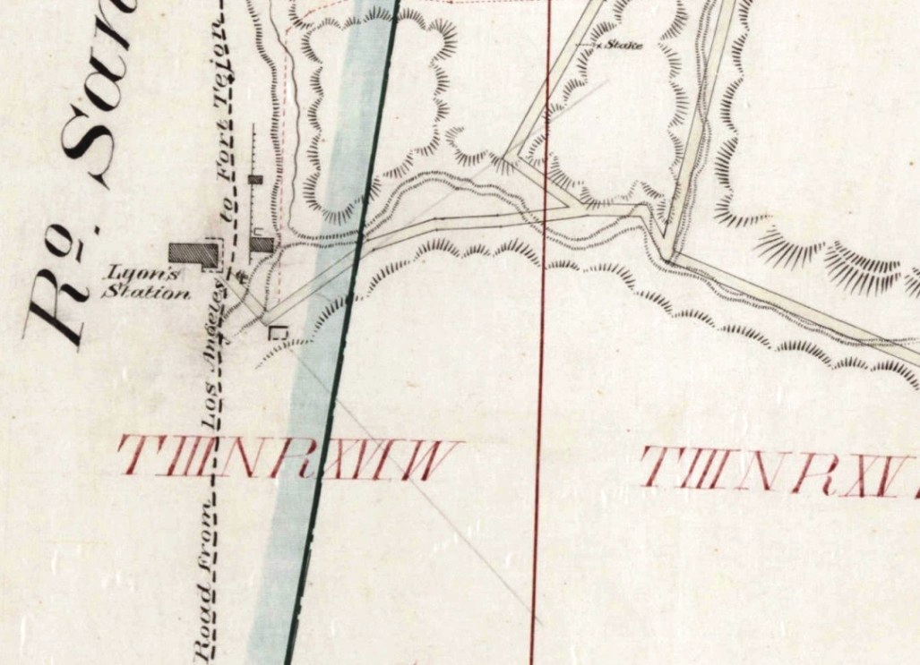
This is a close up of Los Angeles County survey map from July of 1875 that clearly shows the Los Angeles to Fort Tejon stagecoach road running north/south next to Lyon's Station. A road, probably into Elsmere and Whitney Canyon, heads east, since that's the direction of those canyons from Lyon's Station. The Fort Tejon road obviously doesn't run into Elsmere. The map is from the Huntington Library and can be seen here.
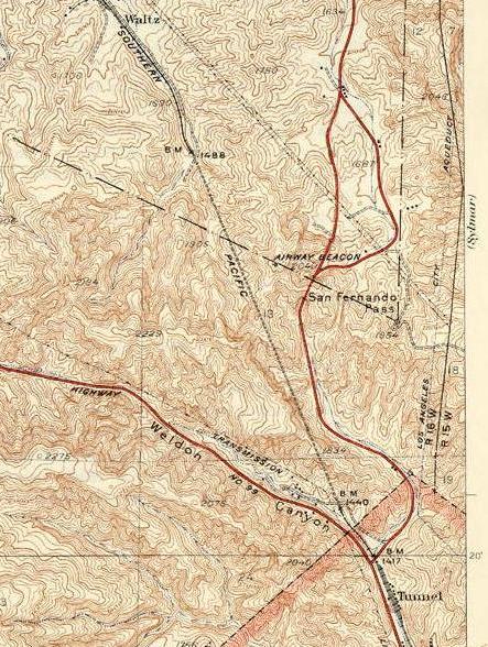
This is a section of the Newhall USGS Quad map edition of 1933. It was surveyed in 1925 and 1929. Part of the Old Road is still on the map. The southeast corner of Rancho San Francisco is shown on the map. The feature known as La Puerta was probably right at the point of the corner on the Old Road.
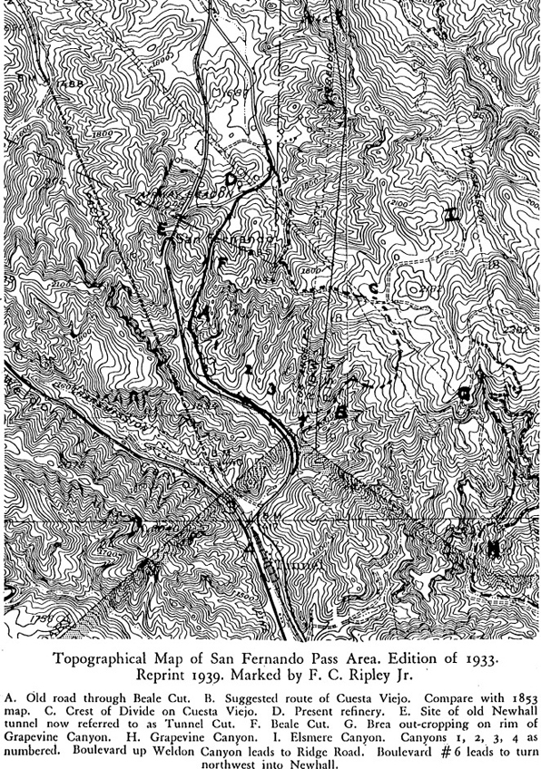
F.C. Ripley Jr. in Part I of The San Fernando Pass, spent time hiking the area and in 1947 and came up with his probable location of the Old Road which he plotted on this map. A PDF version is available here. The pass was destroyed with the construction of State Route 14.
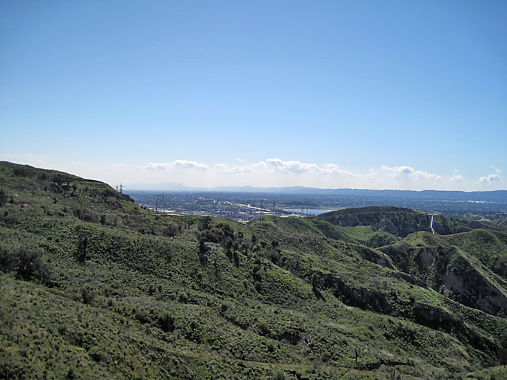
Many travelors on the Old Road (including W.L. Manley in "Death Valley in '49") reported seeing the San Fernando Mission in the distance after they reached the top of the pass. From the top of the mesa where the Old Road supposedly went, is this view in the direction of mission. It is actually about 5.2 miles in a straight line just touching the reservoir on the left side and past it. It is impossible to see it now with all the buildings and trees but a long time ago the mission was the only building for miles around. (Photo taken on 3/13/2010)
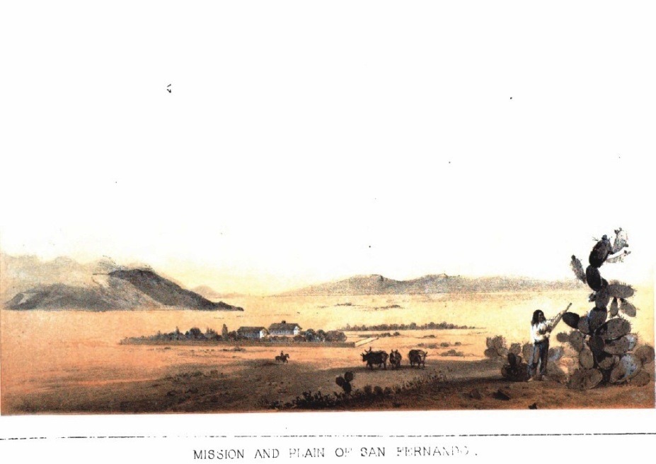
The San Fernando Mission in 1853 when the Williamson expedition saw it. It was just about the only building in the San Fernando Valley. Note the lack of trees. (From Reports of Explorations and Surveys to Ascertain the Most Practicable and Economical Route for a Railroad from the Mississippi River to the Pacific Ocean, Volume 5, Part II, Geological Report, after p. 74)
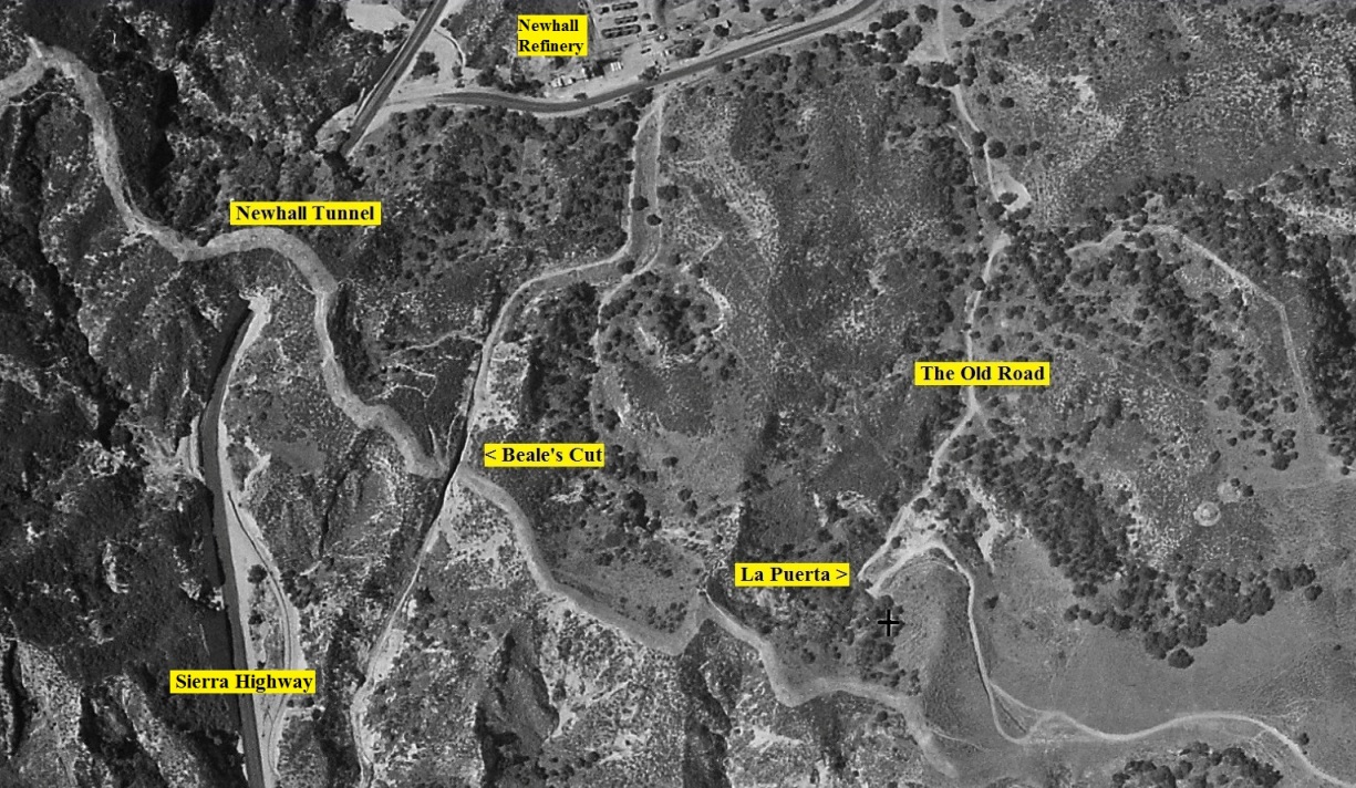
Aerial photo showing the Newhall Tunnel, Beale's Cut (or Fremont Pass), and The Old Road with La Puerta on the hairpin curve. La Puerta (the door) was a feature on the old road at the southeast corner of Rancho San Francisco. It was so narrow there that in the early 1800's, a bar was placed across it to keep cattle from roaming between the Santa Clarita Valley and the San Fernando Valley. The future 14 Freeway would be between Beale's Cut and La Puerta. La Puerta would be cut away by grading for the east sloop. The Newhall Refinery had just opened in early 1930. (FrameFinders website, Fairchild Aerial Surveys, Image c-1001a a-267, Taken July-August 1930.)
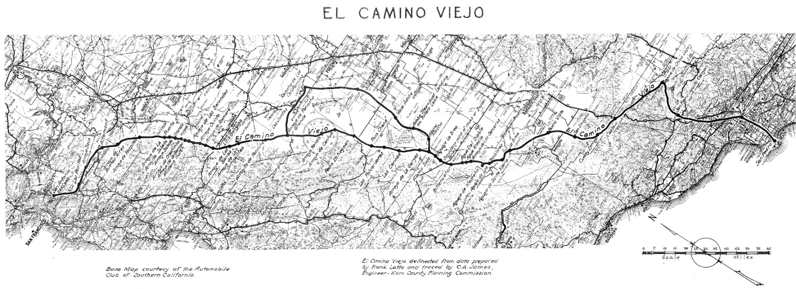
Map of El Camino Viejo (The Old Road) from "El Camino Viejo Los Angeles - The Oldest Road of the San Joaquin Valley" by Frank F. Latta, 2006, Bear State Books, Exeter, California.
Copyright Note: This image is NOT in the public domain and is protected by the copyright laws of the United States.
Used by permission of Bear State Books