Newhall Tunnel
South portal
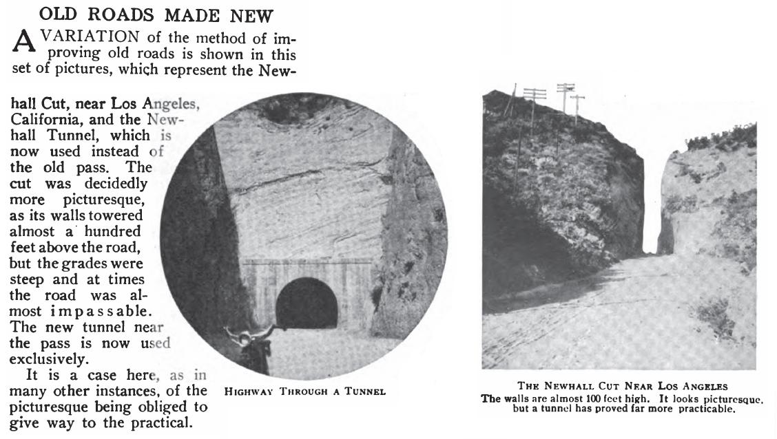
Since the cut in Fremont Pass (it was not called Beale's Cut at that time) was already there, first solutions were to lower it. The Los Angeles Dealers' Association proposed to the Ventura county Supervisors that if they would put proper bridges over Piru Creek and another nearby creek, than the association's good roads fund would be used for "lowering the Newhall cut fifty feet."(LA Times, July 14, 1907)
But another solution was for a tunnel. After a trip by the LA County Highway Commission and County Engineer Arthur L. Loder it was reported that "while in the vicinity of the Newhall grade, the ground was looked over with the view of establishing a new grade. A small canyon was found in which it was believed a small tunnel could be driven at a less cost than it would take to lower the grade of the present road, and if the engineer's survey shows this to be a fact, it is probable something of the kind will be undertaken."(Long Beach Daily Telegram, August 14, 1907)
From the Los Angeles Times, October 4, 1907:
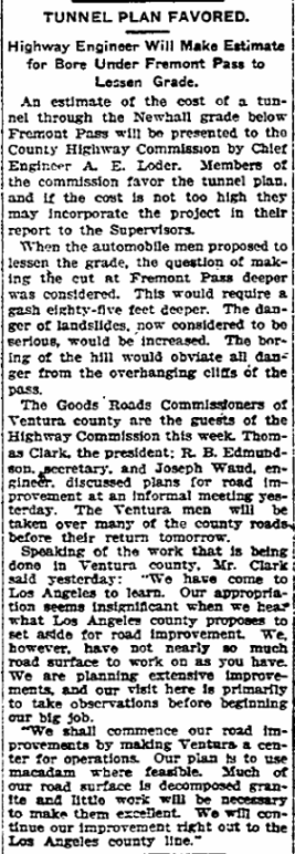
"An estimate of the cost of a tunnel through the Newhall grade below Fremont Pass will be presented to the County Highway Commission by Chief Engineer A.E. Loder. Members of the commission favor the tunnel plan, and if the cost is not too high they may incorporate the project in their report to the Supervisors. When the automobile men proposed to lessen the grade, the question of making the cut at Fremont Pass deeper was considered. This would require a gash eighty-five feet deeper. The danger of landslides, now considered to be serious, would be increased. The boring of the hill would obviate all danger from the overhanging cliffs of the pass."
From the Los Angeles Times, October 20, 1907:
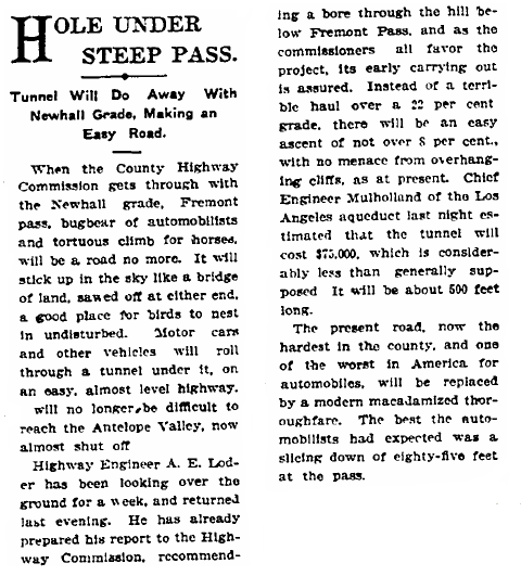
"Fremont Pass, the proper name for Newhall grade, is the steepest hill in the United States on a public road. At the summit, the perpendicular walls are seventy feet deep, and the cut is but fourteen feet or less in width." "As planned by the Highway Commission, all this last steep of the pass and the big cut will be abandoned, and a side canyon used. This little canyon opens off the present road on the left side." "A temporary wagon road runs into this canyon to a test oil well that was operated there four years ago. Where this little ravine ends the county officials intend to bore a tunnel about 500 feet long, to cost about $100,000. If this is done it will require at least a year to complete the work, so that it will be necessary to use the present pass for some time to come."
From the Los Angeles Times, March 7, 1908:
"But in one way the most important work undertaken by the Highway Commission, and a work which is already surveyed and practically complete as to plans, is that for reducing the Newhall grade from 22 percent to about 6 percent, on the San Fernando road, the great northern highway. The present grade on this road between San Fernando and Newhall makes almost prohibitive trucking of farm products from the northern valley to Los Angeles. The commissioners and Engineer Loder have discovered that by turning the road in a southerly direction just about a mile and a half this side of the old adobe building, a relic of pioneer days, and following the canyon in which an old abandoned oil derrick is the principle landmark of civilization, the heavy grade can be eliminated. It is estimated that this route for the San Fernando road, including the tunnel, will cost about $50,000, but what it will mean to the two ends of Los Angeles county can hardly be measured in dollars."
Money for the project would come from a bond issue of $3,500,000 that would have to be approved by the voters. It was easily passed in July of 1908.(Los Angeles Times, July 31, 1908) Now the Newhall tunnel could be built.
From the Los Angeles Herald of November 21, 1909:
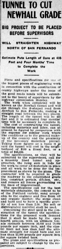
"Plans and specifications for one of the biggest pieces of engineering work in connection with the construction of county highways under the issue of the good roads bonds will be submitted to the board of supervisors by the highway commission Monday. The work when completed will be known as the Newhall tunnel and will cut through the S-shaped road from Newhall to San Fernando, making a straight road between the two places. The length of the tunnel will be 435 feet and it is estimated four months' time will be necessary to complete it. The cost of constructing the tunnel, including materials and labor, can at present be figured by comparison with the expense for similar work where like conditions as to the general makeup of the country and the proximity of the necessary materials prevail. Taking these figures as a basis it is said the tunnel will cost in the neighborhood of $100 a lineal foot, or a total of $43,500."
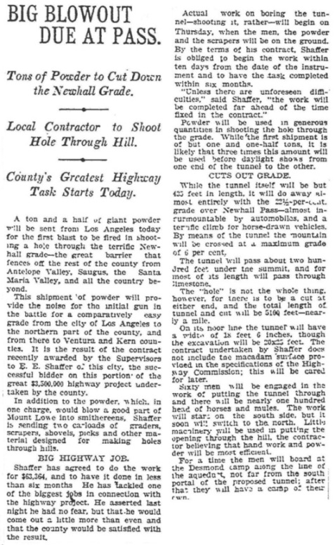
In December of 1909, the Board of Supervisors awarded the contract for the construction of the tunnel to E.E. Shaffer of Los Angeles. He was the successful bidder agreeing to do the job for $63,364. By the terms of his contract, Shaffer must begin the tunnel work withing ten days from the date of the instrument and to have the task completed within six months. Work would begin on Thursday the 30th. Shaffer said that "unless there are unforeseen difficulties, the work will be completed far ahead of the time fixed in the contract." Also reported was that "sixty men will be engaged in the work of putting the tunnel through and there will be nearly one hundred head of horses and mules. The work will start on the south side, but it soon will switch to the north. Little machinery will be used in putting the opening through the hill, the contractor believing that hand work and powder will be most efficient." The men would have their own camp near the tunnel site where they could live. There was cutting and grading needed on both sides of the tunnel, making the whole project about 5100 feet in length. The contract did not include preparing the road surface. That would be done after the tunnel was completed. (Los Angeles Times, December 28, 1909)
On June 20, 1910, the Board of Supervisors granted Shaffer an extension from July 1 to August 31, 1910. A hard conglomerate was slowing down progress. It would need more blasting work than was expected.(LA Herald, June 21, 1910)
Due to changes in the tunnel specifications, cost was increased by $1816. Another extension for completion was given to Shaffer. The new date was October 31. Shaffer declared that "he will have finished the concreting of the interior and effected the removal of the core and in all respects will have it ready for use."(LA Herald September 8, 1910)
The Los Angeles Herald reported on December 6, 1910 that:
"A. E. Loder, chief engineer of the highway commission, recommended to the board of supervisors yesterday that a bronze tablet bearing the names of the board, the contractor, the highway commission and himself be placed at the entrance to the Newhall tunnel in commemoration of its completion. He said the tablet could be secured at a cost of $125 or two tablets for $175. Loder said, however, that he thought one tablet would be sufficient. The matter was taken under advisement." This would be done.
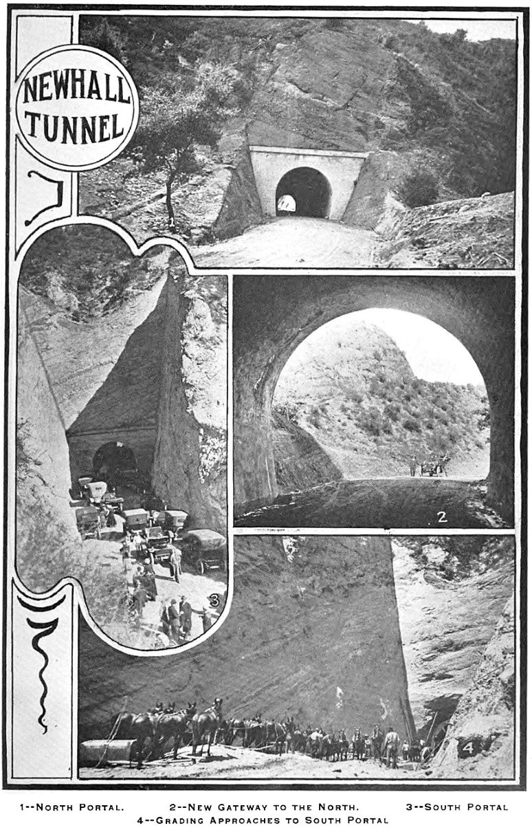
The Los Angeles Herald of December 12, 1910, reported that "The great Newhall tunnel will be thrown open to the public next Monday, December 19." However, the date was postponed to the 21st (see article below).
From the Los Angeles Evening Express of December 21, 1910: "More than 80 automobiles, carrying from five to seven persons each, started from the chamber of commerce shortly before 9 o'clock this morning for the run to Newhall tunnel, to witness the formal opening of that important link in the Los Angeles county good roads system."
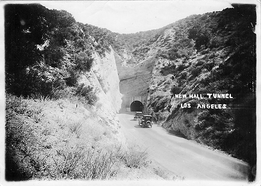
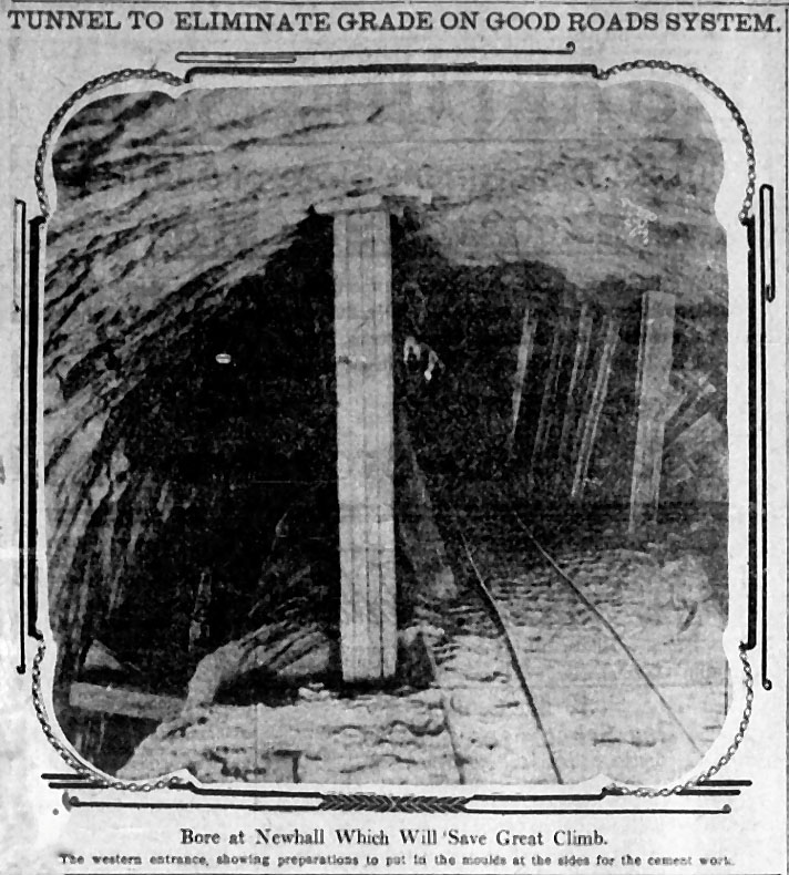
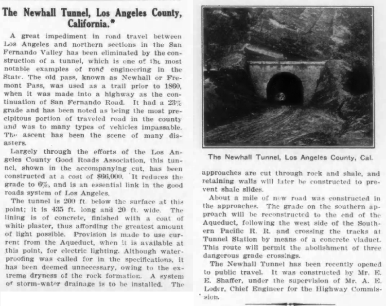
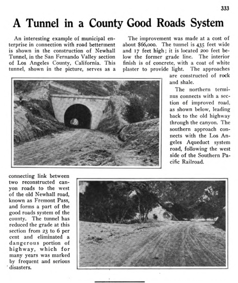
The total length of the finished tunnel was 435 feet. It was 17 feet high and 17 feet 5 inches wide. It was about 200 feet below the summit and about 250 feet below Fremont Pass (Beale's Cut). The road grade was reduced from about 26 % through the Cut to about 6 % through the tunnel.
In 1917, this road became part of the State Highway system as Route 23. It would later become Route 6 and then Sierra Highway.
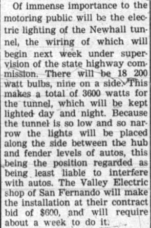
The light situation in the Newhall tunnel was a problem from the very start. Even the design of the tunnel took it into consideration. "As there was no artificial means at hand of lighting the tunnel it was quite necessary to make the actual tunnel as short as possible. For this reason, and in view of the fact that the material had stood in high vertical walls in the old cut 500 ft. to the east, the south portal was cut back 300 ft. and moved 60 ft. further north than otherwise would have been necessary. As now built the curved wall reflects some light through the tunnel to good advantage during the greater part of the day. On completion it was decided that the general appearance and the distribution of light through the tunnel could be improved by plastering. As a result of the plastering an attractive surface has been secured, and it is said that the distribution of daylight through the tunnel has been greatly improved." (Engineering Record, May 20, 1911, Vol. 63, No. 20, p. 567.)
In February of 1924, lights were finally added (Newhall Signal, February 22, 1924). The lights were scheduled to be on day and night. However, soon after that in July of 1924, the lights were turned off "in harmony with the program of power conservation in Southern California, Division VII" (p7, California Highways, July 1924). The Newhall Signal of July 21, 1927, reported that "The interior of the Newhall tunnel is being painted a brilliant white, which much improves the light, and makes it much easier to drive through."
By the middle 1920's, the narrow tunnel was beginning to become a bottleneck to traffic. Motorists began demanding a solution. The number of automobiles registered in California in 1910 was 44,132. The number registered in 1927 was 689,902. The population in Los Angeles County increased from about 504,000 to 2,250,000. These increasing numbers were causing the bottleneck. On May 1, 1927, in a 24 hour period 24,480 autos carrying more than 75,000 people passed through the tunnel.(Van Nuys News, June 17,1927)
Early proposals were to construct a new tunnel or construct a road over the summit near Fremont Pass. Another idea was to construct a road from San Fernando up to the Pacoima Dam and then to Sand Canyon. From there it would go either up Mint Canyon or Soledad Canyon to the Antelope Valley.
In October of 1929, a contract was awarded to McCray Company of Los Angeles to change the alignment of the just north of the tunnel. Up to 1930, the road going north exited the tunnel and turned to the right (east) onto today's Clampitt Road. Then the road followed a wide loop to where it runs into today's Sierra Highway and continued on to Newhall. The new road would go straight north from the tunnel and run into the point where Remsen Road joins Sierra Highway, basically following today's alignment. That would shorten and straighten the road. The contract price was for about $70,000 for a length of 1.1 miles. It was finished in June of 1930 (info from California Highways and Public Works magazine).
But something still had to be done about the bottleneck at the tunnel.
Los Angeles Times, October 4, 1907
Los Angeles Times, October 8, 1907
Los Angeles Herald, November 21, 1909
Los Angeles Times, December 28, 1909

Los Angeles Times, February 25, 1910, during construction.
Los Angeles Herald, April 17, 1910
Pre-completion description of tunnel construction from Municipal Engineering magazine of May 1910
Los Angeles Times, September 14, 1910.
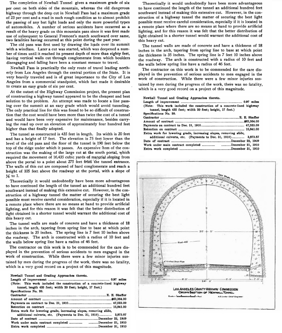
From the Los Angeles County Highway Commission Semi-Annual Report for Period Ending December 31, 1910.
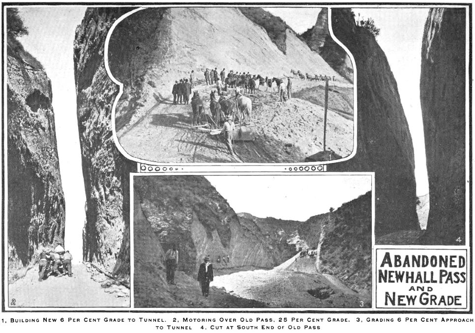
Image from previous Los Angeles County Highway Commission Semi-Annual Report for Period Ending December 31, 1910.
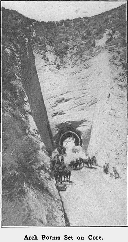
Another image from previous Los Angeles County Highway Commission Semi-Annual Report for Period Ending December 31, 1910.
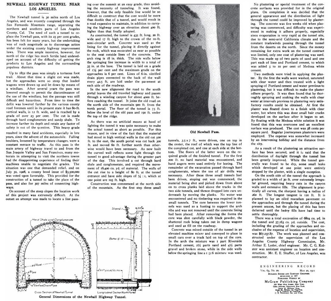
Complete description of tunnel construction from the Engineering Record weekly magazine of May 20, 1911 (p566-567). Note that the construction did not include any lights, but construction plans took that into account.
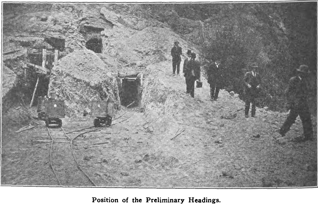
Image from the previous Engineering Record weekly magazine of May 20, 1911.
Another image from the previous Engineering Record weekly magazine of May 20, 1911.
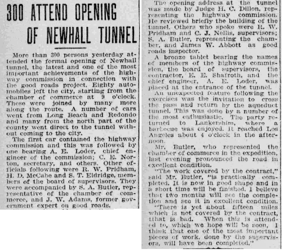
Official opening on December 21, 1910. Article from the Los Angeles Herald of December 22. Note that a bronze tablet was placed at the south entrance to the tunnel.

The Los Angeles Rubber Stamp Company manufactured the tablet. This is from their Catalogue No. 20, circa 1920. Description from catalogue:
"Bull Metal Bronze Tablets - Machine cut and hand finished. The combination of metals in these tablets is made from a special formula of our own, the base of which is copper, it being best adapted for this class of work. Rich and artistic in color and very durable either for outside or inside exposure, improving with age. When the plates are ready for lettering they are from one-half inch to three-fourths of an inch in thickness, varying according to size of tablet. The letters are cut to stand out about 1/8 inch from a stippled background. Each letter is carefully cut and accurately finished by hand, requiring much time and care."
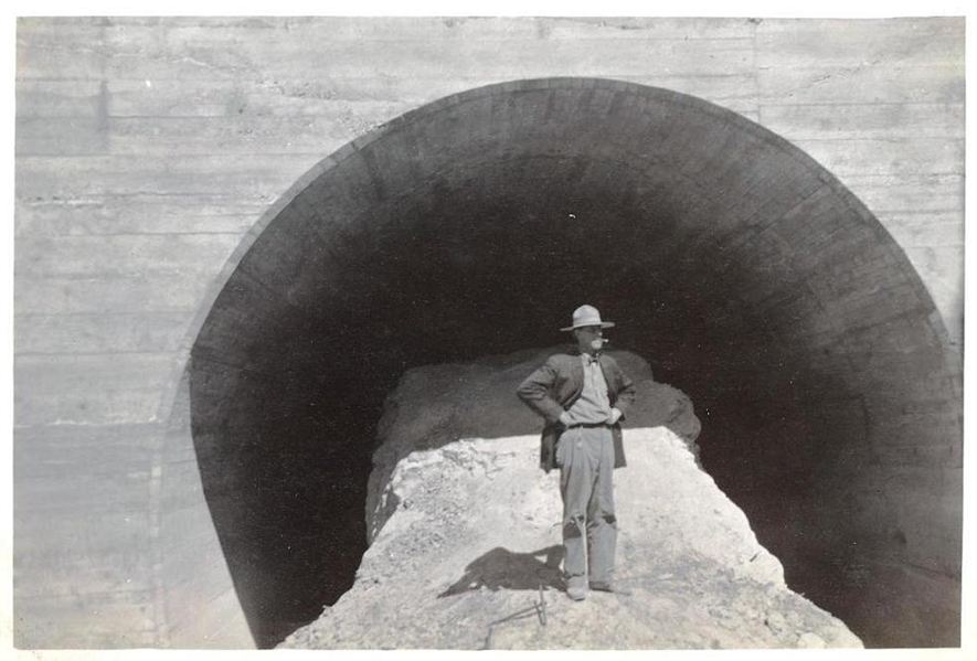
Title: "Newhall Tunnel" (1912)
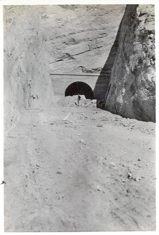
This photo is dated 1912, two years after the tunnel opened, but it looks to me that the tunnel is still under construction. Everything looks freshly cut. This photo (and the next one) must have been taken in 1910 before the tunnel was opened.
Source: Lippincott Collection, Water Resources Center Archives - University of California, Berkeley
Copyright Note: This image is not in the public domain and is protected by the copyright laws of the United States.
Used by permission of the University of California, Berkeley, Regents.
Title: "Newhall Road Tunnel" (1912 - but probably before that)
Source: Lippincott Collection, Water Resources Center Archives - University of California, Berkeley
Copyright Note: This image is not in the public domain and is protected by the copyright laws of the United States.
Used by permission of the University of California, Berkeley, Regents.
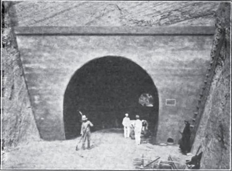
From the Good Roads Magazine of May, 1911. Maintenance work appears to be in progress. This is the south portal.
From Engineering News, Vol. 65 No. 21, May 25, 1911, p. 632 (north portal photo).
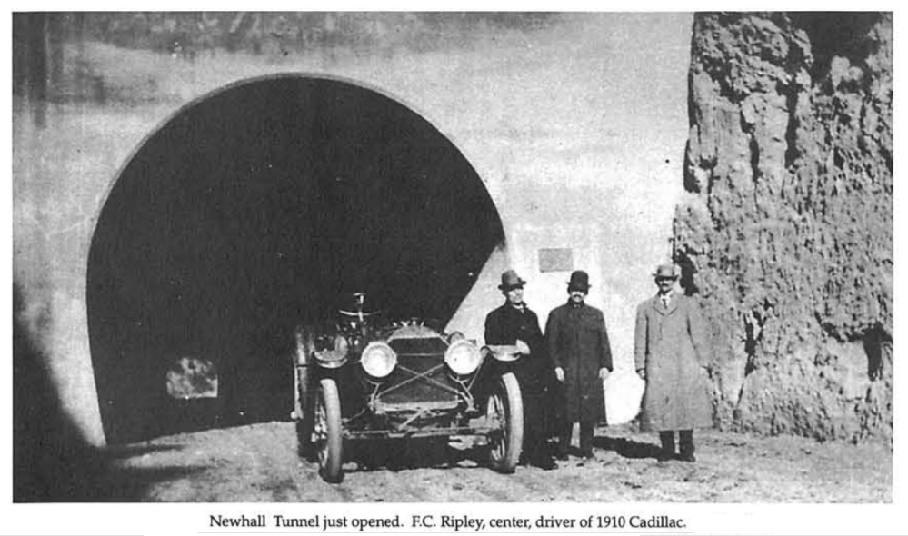
From the collection of F.C. Ripley. This photo was in The San Fernando Pass and the Pioneer Traffic that Went Over It by Vernette Snyder Ripley, Part IV, The Quarterly, Historical Society of Southern California, June 1948, Vol. XXX, No. 2. Frederick Chandler Ripley (1877-1960) was the husband of Vernette Ripley (1879-1961). The rectangular bronze tablet is mounted on the concrete just behind Ripley.
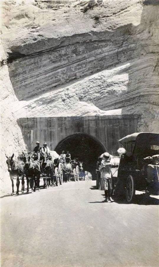
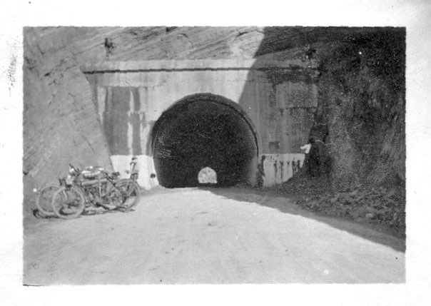
Waiting for the wagons (date unknown, but probably before 1915)
This image is NOT in the public domain. It is owned by Brad Therrien and used with his permission.
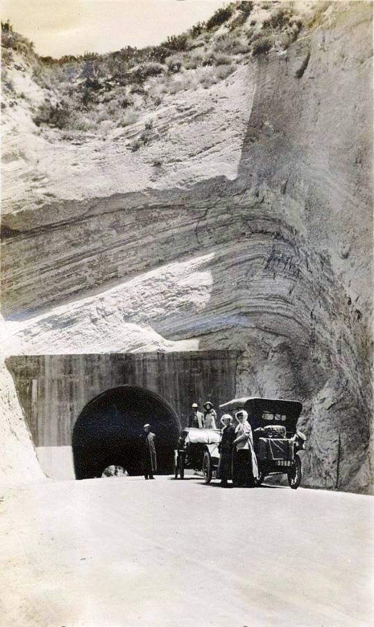
Wagons gone, now take your own photo.
This image is NOT in the public domain. It is owned by Brad Therrien and used with his permission.
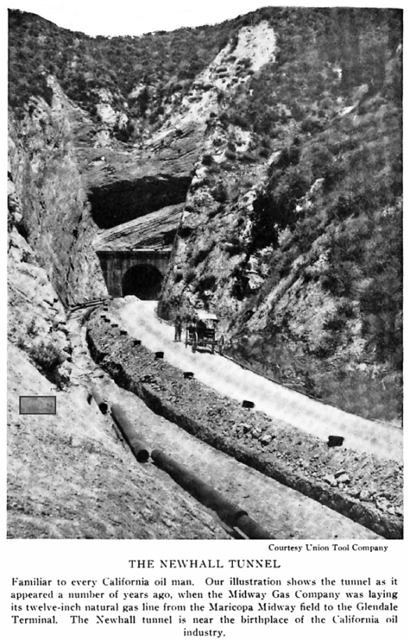
Photo taken in 1912 or 1913 when the gas pipe was being laid. From the Oil Bulletin, Official Monthly Magazine, Chamber of Mines and Oil, Los Angeles, California, Vol. XI, No. 8, August 1925, p. 803.
From Technical World Magazine of May, 1913
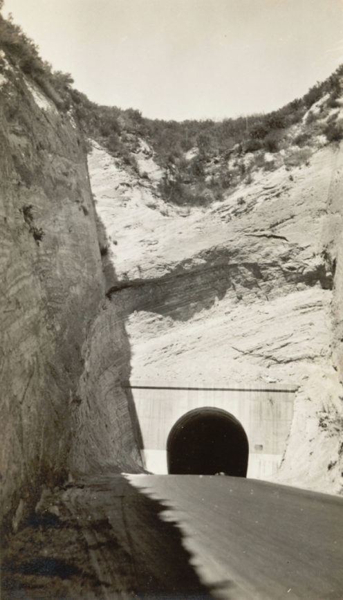
South portal dated 1914
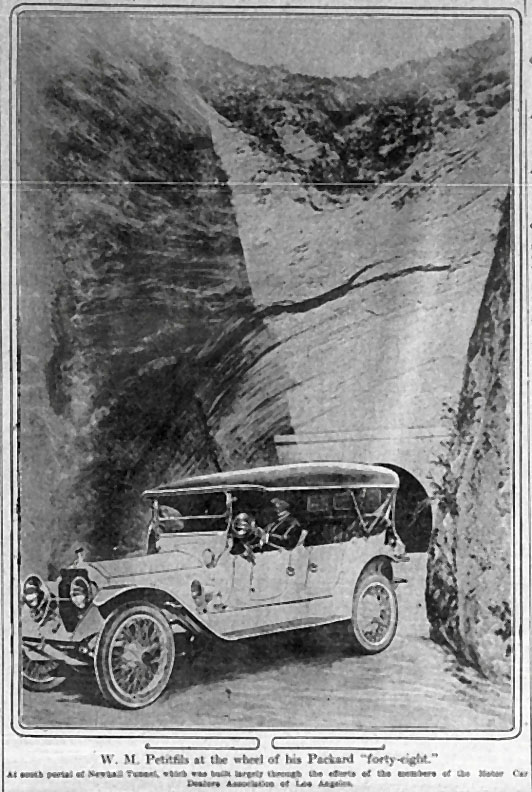
Los Angeles Times of January 31, 1915
Article from the Town & Country Edition of The American City of April 1916. This is the north portal (entrance) of the tunnel.
Title: Fremont Pass Road now in use. Photographer: William H. Frick.
From: The Los Angeles Aqueduct, Itinerary of the Water of the Los Angeles Aqueduct From its Source to 1837 Canyon Drive, 1917.
The Huntington Library, San Marino, California.

World War 1 plans for guarding Los Angeles County included holding the Newhall Tunnel from invading forces from the north or northeast. A few men armed with rifles and machine guns could hold thousands of enemy troops at bay. At least, that's what the Los Angeles Police Department thought. They don't seem to be considering that Fremont Pass was right next door to the tunnel. To quote: "Newhall tunnel, in case word being received that the enemy was approaching from that direction, could be reached with autos filled with members of the Home Guard in forty minutes (it being understood that in a case of that kind the deputy sheriffs would not only close their eyes to speeding, but join in the chase themselves to guard the passes)." Los Angeles Times of April 22, 1917.
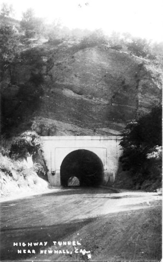
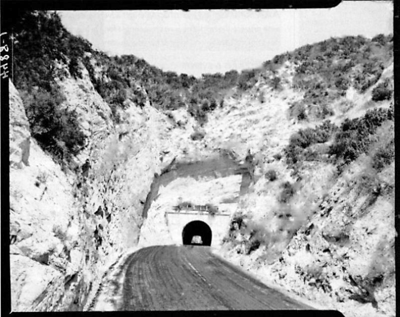
South portal (entrance) of the tunnel. The rock beds in this area slope down to the west. Can't make out the sign on the left. The bronze tablet is on the right.
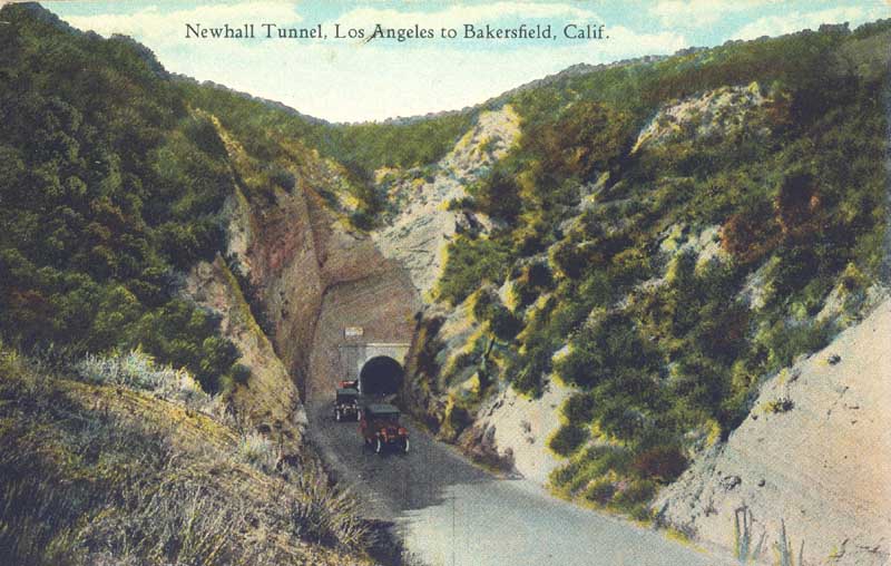
Postcard of south portal. This is a very common postcard. The road up to the entrance curves to the right. On the north portal, the road curves to the left.
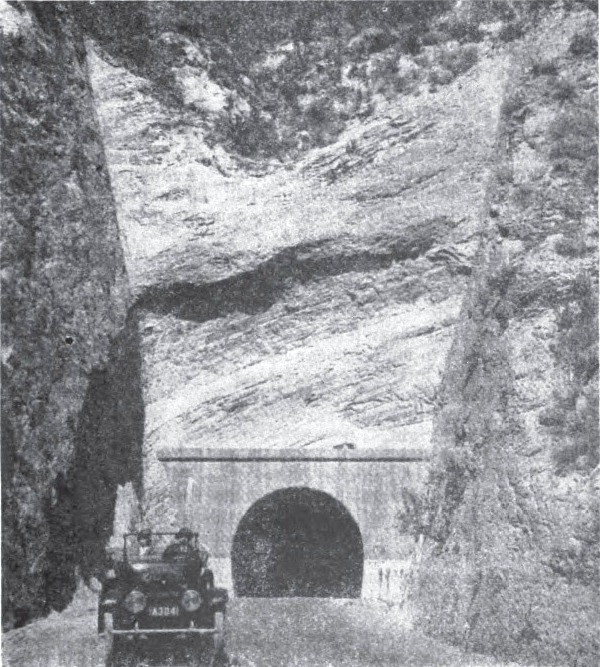
From the Official Automobile Blue Book of 1919
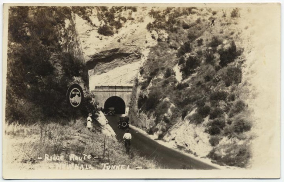
Title - "Ridge route, Newhall tunnel" - 1920's postcard. The sign says "They Cool" (meaning the mountains).
Copyright Note: This image is NOT in the public domain and is protected by the copyright laws of the United States.
Courtesy of the California History Room, California State Library, Sacramento, California.
Tunnel lighting added from the Signal of February 22, 1924.
Lights turned off. From California Highways magazine of July, 1924
North portal. The road up to the entrance curves to the left. The rock beds are still dipping to the west, the right hand side of the photo. Electrical junction box attached to left part of tunnel making this a 1924 or older photo.
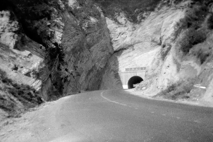
Photo 1 from the Coblentz family vacation of 1926. This and the next photo I bought from ebay. I don't know who the Coblentz family was.
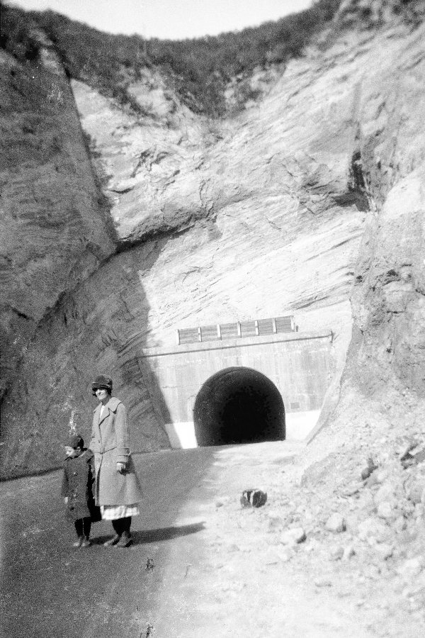
Photo 2 from the Coblentz family vacation. Just above the tunnel is a short wooden barrier to stop rocks from dropping directly on cars.
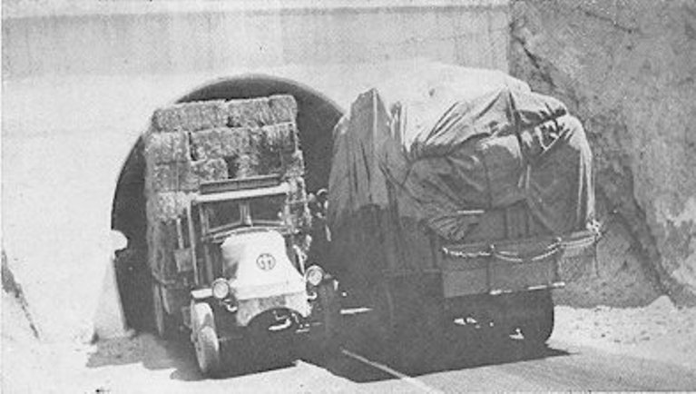
At a little over 17 feet wide and high, larger trucks had problems driving through the tunnel. Two trucks going in opposite directions would have a big problem.
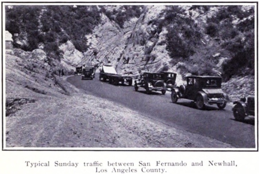
1927: "Typical Sunday traffic between San Fernando and Newhall, Los Angeles County." (From California Highways and Public Works, Vol. 4, No. 8, August 1927, p. 10)
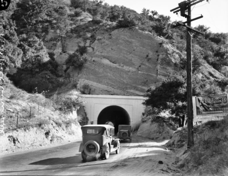
June 1928, south entrance. From the Los Angeles Times Photographic Archive, Department of Special Collections, Charles E. Young Research Library, UCLA.
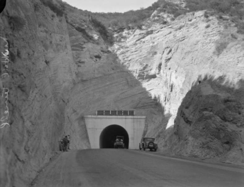
June 1928, south entrance. From the Los Angeles Times Photographic Archive, Department of Special Collections, Charles E. Young Research Library, UCLA.
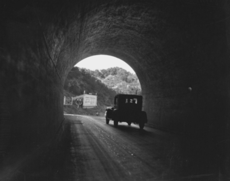
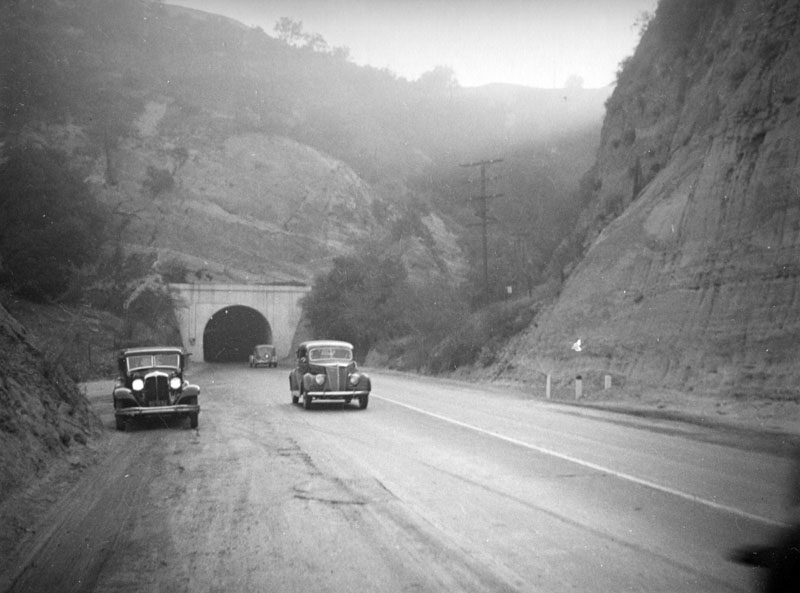
June 1928, from inside the tunnel exiting the north entrance. From the Los Angeles Times Photographic Archive, Department of Special Collections, Charles E. Young Research Library, UCLA.
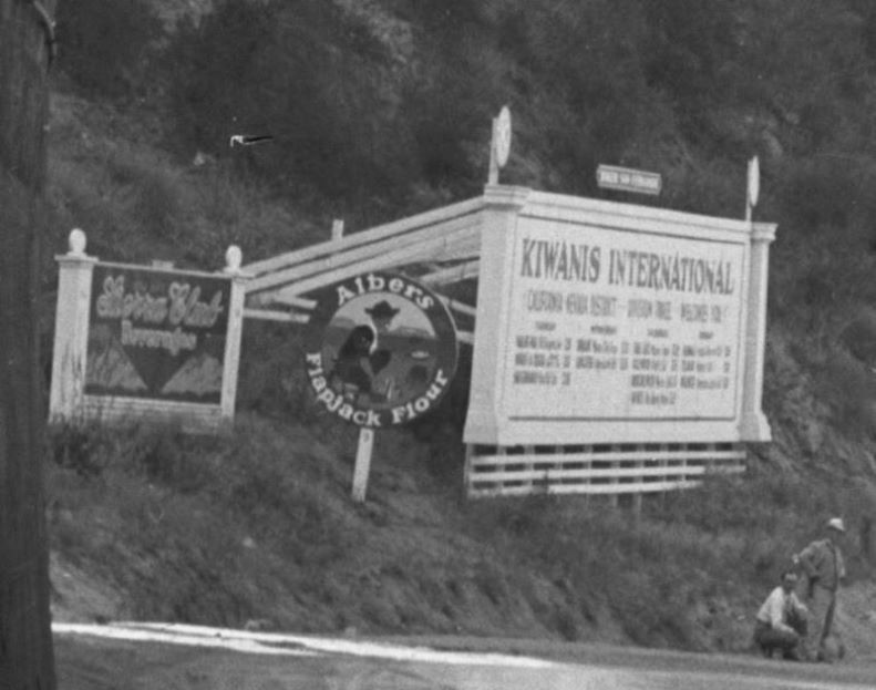
Closeup of signs in previous photo.
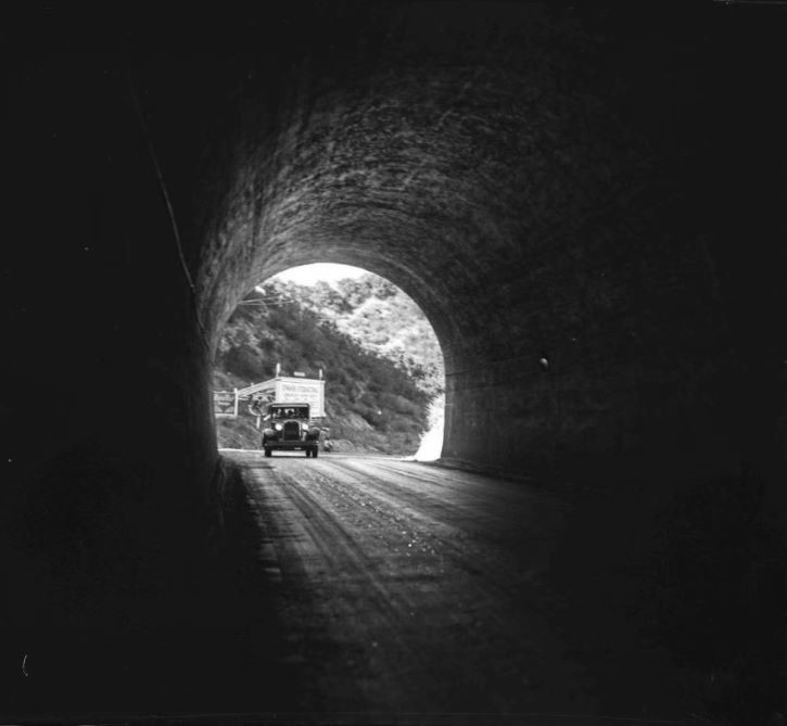
Two photos in the tunnel were taken at the same time - the previous full photo and this one, where the car is entering the north portal. This one was was actually printed in the July 1, 1928, edition of the Los Angeles Times. From the Los Angeles Times Photographic Archive, Department of Special Collections, Charles E. Young Research Library, UCLA.
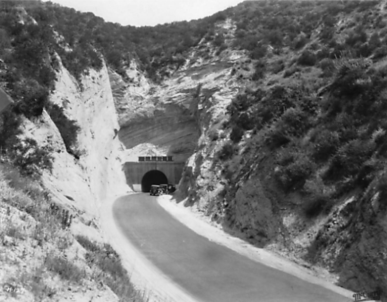
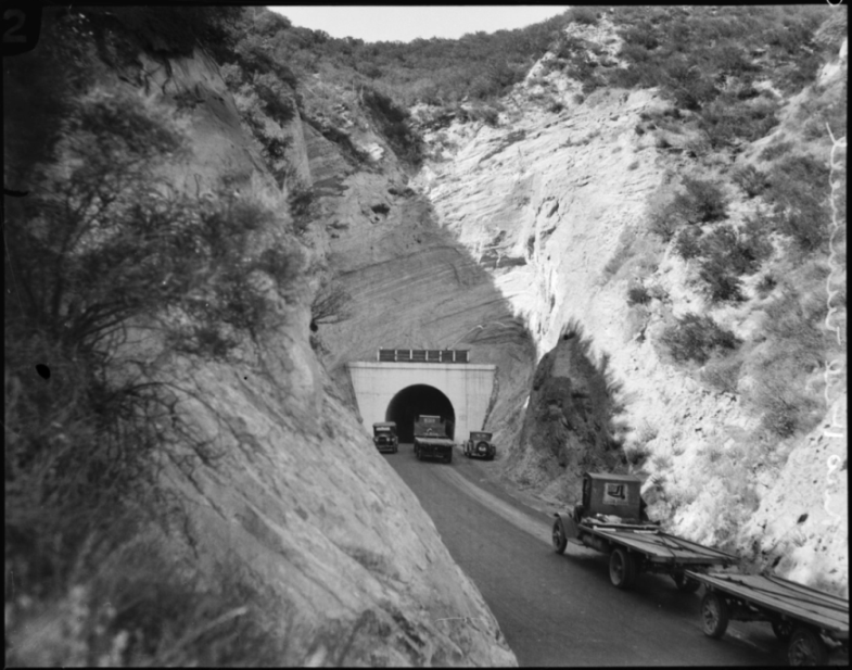
Late 1920's. From the McCurry Album Collection, California Department of Transportation Library.
June 1928, north entrance. Note the utility pole on the right with the wires strung down to the junction box on the left side of the tunnel. Lights in the tunnel were installed in February on 1924 but were turned off in July of the same year. From the Los Angeles Times Photographic Archive, Department of Special Collections, Charles E. Young Research Library, UCLA.
1937 - South portal, from Westways magazine, November/December 2011.
1937 - North portal (photo by Herman J. Schultheis)
Copyright Note: This image is NOT in the public domain and is protected by the copyright laws of the United States.
Used by permission of the Herman J. Schultheis Collection /Los Angeles Public Library.
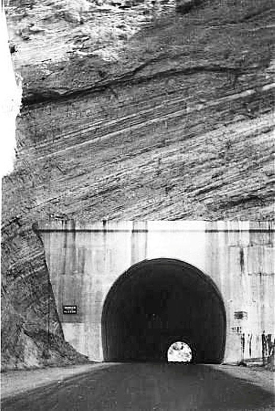
North portal. "Above old tunnel portal terrain on line of cut rises to height of 200 ft.", From Construction Methods, January 1940, McGraw-Hill Publishing Company, New York, p.64.
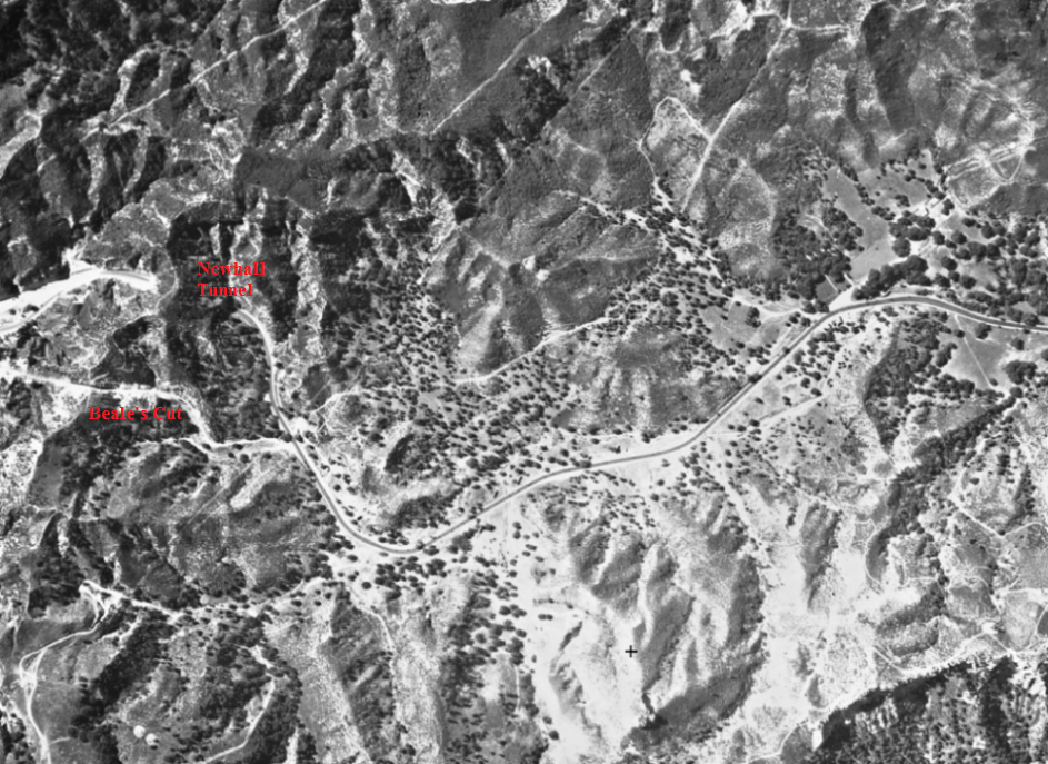
Aerial photo taken sometime in 1928 showing the old alignment. The Newhall Tunnel and Fremont Pass (Beale's Cut) are on the left.
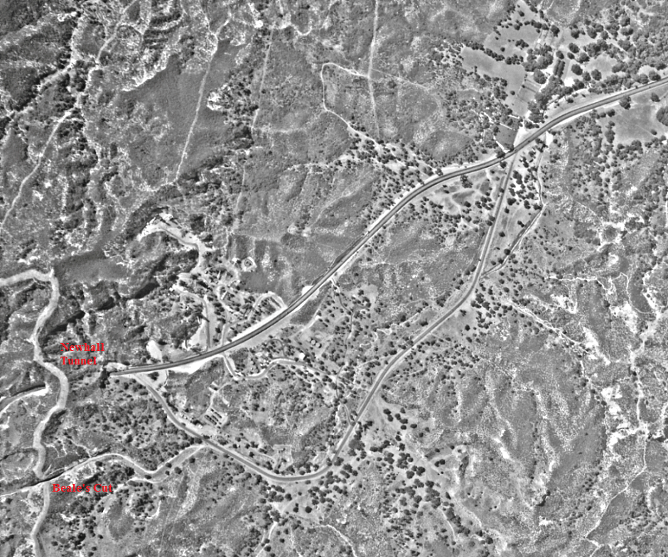
Aerial photo taken between July 18, 1930 and August 25, 1930 showing the new alignment with no curve.
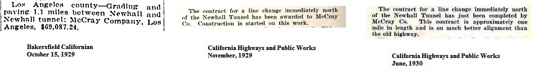
Articles about the realignment work
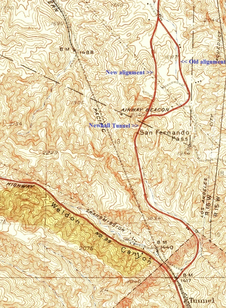
1933 edition of the USGS topographic map of the Newhall Quad. The older alignment of the road has now been replaced by the new 1930 alignment to the north. This map also shows the new Weldon Canyon Road (Highway No. 99), built to relieve some of the traffic at the tunnel. At the bottom right of the map is Tunnel Station (marked as only Tunnel).
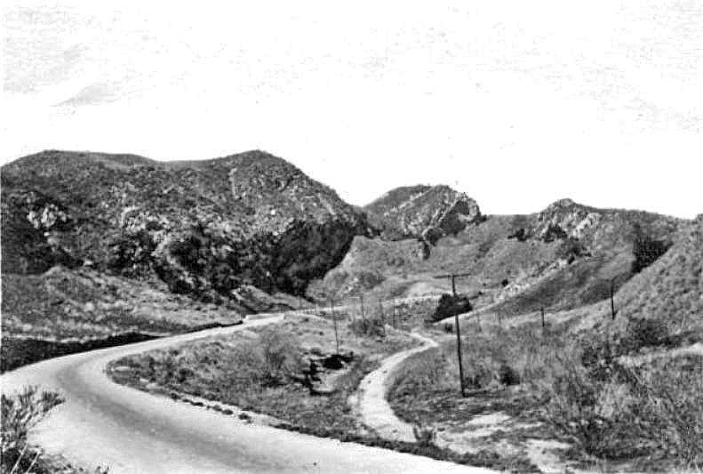
The road to the tunnel in 1914. The old road to Fremont Pass is on the right, closer to the creek bed.
Newhall grade just south of Newhall Tunnel looking west (Photo taken 1/23/1928 by Lynne M. Correll).
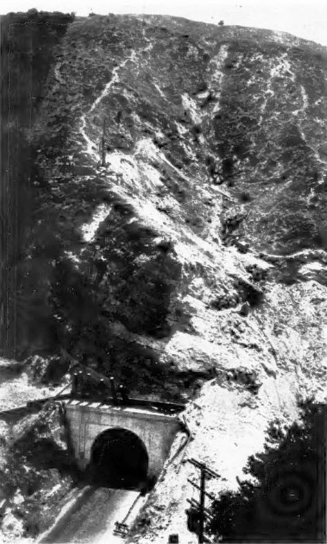
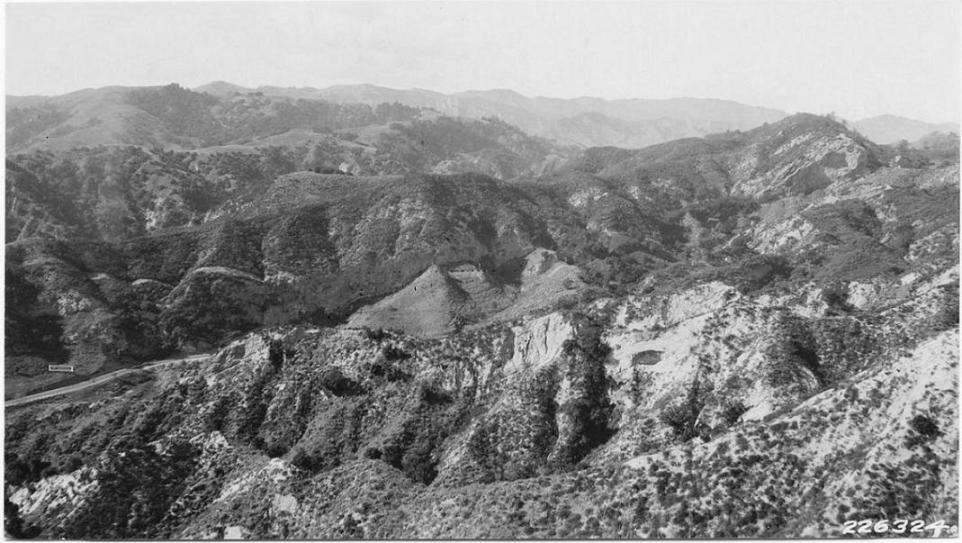
Photo caption: "Vicinity of the Newhall tunnel. Knife like ridges with vertical eroded sides are characteristic of this region. Chamise and sage are the common types." Image from the Wieslander Vegetation Type Mapping Collection are courtesy of the Marian Koshland Bioscience and Natural Resources Library, University of California, Berkeley, http://www.lib.berkeley.edu/BIOS/vtm/

About the same view almost 80 years later (Photo taken 2/17/2007)