"The man in charge [Spangler] frankly admits that the difficulties to bore in this country compared with those in Pennsylvania are insuperable. But like all of us he is impressed with the idea that there's lots of oil somewhere below him. The well is properly located in my opinion and if they can get it down to any considerable depth ought to test the question pretty thoroughly. Salisbury [Albert J. Salisbury - a driller for Bard] was with me and we both are of the opinion that...their machinery, engine power and size of hole are all inadequate for sinking to a greater depth than 600 feet."It might be interesting to read what the newspapers of the day had to say about the progress of the first oil well in the San Fernando Petroleum Mining District using steam power:
"A car-load of machinery, boring tools, steam engine, etc., leave the depot to-day by the San Fernando train for the Temple petroleum claims. Ten or twelve men will be set to work immediately, and the most energetic means will be provided to fully develop the oil-producing capacities of this well known region."LA Herald of 6/28/1874:
"There can be no doubt but that the supply of crude petroleum is almost inexhaustible. One boring company with steam power and tools and all the modern improvements, under the supervision of an experienced well-borer from Pennsylvania, is now sinking a well; and another company is forming and will soon commence operation. There is an ocean of oil in the belt, and the facilities that this company have for refining will forever guarantee to them its control. The company have resolved to establish a refinery in this city of sufficient capacity to meet all demands, and the proceeds of stock sold will be invested in suitable buildings for that purpose."LA Evening Express of 7/12/1874:
"The works on the Temple claim are now completed, and boring will commence in a few days. Mr. Spangler, the energetic Superintendent, has within a few weeks constructed roads, erected the necessary works for boring and has got the machinery on the ground and will to commence to bore immediately."LA Evening Herald of 7/23/1874:
"The well has thus far been sunk to the depth of forty feet and has already commenced to fill with oil. By next week it will be down 150 feet. It is proposed to bore to the depth of 400 feet when a steady flow of oil will doubtless be secured. Two shifts of hands will be run next week in order to hasten the work."LA Herald of 7/25/1874:
"The well on the Temple claim is now down fifty feet, and the prospects are very good."LA Herald of 8/2/1874:
"The well on the Temple claim is down between seventy and eighty feet. The machinery is in perfect order and works like a thing of life. The workmen are drilling from seven to ten feet per day. At present they are in shale formation with considerable oil and gas coming in. The oil has changed to a green color in the last ten feet, which is very favorable for a good quality. Mr. Spangler, who is boring this well, has had considerable experience in Pennsylvania, and he says that the indications are favorable for a flowing well in less than 200 feet, but he intends to sink it 800, if the flow of oil does not prevent."LA Herald of 8/6/1874:
"The San Fernando OIl-well Boring Company had a meeting yesterday in this city. The Secretary's report showed an expenditure, up to the present time, of seventeen hundred dollars. Mr. Spangler, the Superintendent of the well, was present and reported that the well was ninety-four feet deep, with considerable oil running into it; that they drilled seven to nine feet per day; and that everything was in perfect order, and working like a charm. When we consider the work that has been done, and the material on hand, we must commend this Company for economy. Fifteen hundred dollars, the amount paid for an engine and set of tools is said to be very cheap. This does not include the derrick, freight, and labor of putting the machines up."LA Herald of 9/9/1874:
The Spangler well has been reamed out to seven and a half inches, preparatory to putting in large casing to shut off surface water and overcome the difficulties encountered by the caving in of loose shale. The well will again be in running order in a week or two."LA Herald of 9/26/1874:
"The company now boring on the Temple claim could pump four barrels per day, and feel confident that they will get a hundred barrel well before reaching the depth of 300 feet."LA Herald of 10/11/1874:
"The well is now about two hundred feet deep. The oil is within four feet of the top of the well, with immense volume of gas escaping."San Francisco Chronicle of 10/18/1874:
"This well is now 160 feet, and the oil rises to within four feet of the surface. They are still boring, however, expecting to strike a stronger vein within a short distance."LA Herald of 1/13/1875:
"The oil is so abundant in what is known as the 'Temple well,' that it is estimated forty barrels per day might be pumped from it."LA Evening Express of 3/15/1875
"It is reported that a flowing well of very superior oil has been struck on the Temple Company's claim at San Fernando, and that it now flows at the rate of twenty-five barrels per day."LA Herald of 3/28/1875:
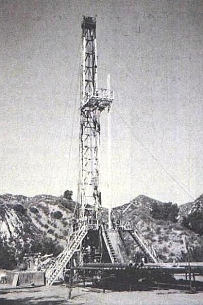
"The boring apparatus of the Temple well comprises a derrick of about fifty feet high, a little portable engine, covered by a shed, and a small shanty to the operatives. Everything about the place has a sort of mourning aspect, the drills, tackles, machinery and structures being bespattered and coated with the black, oily petroleum. As it was Sunday, the men were not at work, and we found only the cook of the party at home."..."We learned afterward that the well had been sunk to a depth of 200 feet. On the preceeding Sunday the workmen had struck oil and set to work pumping it out. This procedure only lasted about 24 hours, however, and resulted in securing 35 barrels of petroleum, when the sand through which the well was bored caved in, and put a quietus upon further proceedings. The operatives are now engaged in taking out this obstruction and sinking pipes to prevent similar accidents hereafter."LA Herald of 4/27/1875:
"Mr. Miller, one of the workmen at the Temple oil well, came to the city Saturday for a stay of several days. He informs us that the sand had been cleaned out of the well and the drill is still going down, having now reached a depth of 280 feet. The workmen are pumping about four barrels of oil a day. The prospect continues good for a flowing well."LA Herald of 5/2/1875:
"One on the Temple claim commenced some months ago, the manager of that well reports a depth of 280 feet with large volumes of gas and a production of about five barrels of oil per day, though laboring under every disadvantage, they have pushed the work with a persistence worthy of the cause and are going still deeper."LA Evening Express of 6/21/1875:
"The Temple well is down to a depth of 250 feet and is full of oil of a quality that has never been surpassed on this Coast. The oil runs into the well so fast that the men cannot exhaust it with a sand pump. Mr. Spangler, the Superintendent, says that he has struck in this well the regular oil sand found in the successful Pennsylvania wells. This is considered one of the best indications obtainable, and everybody is greatly encouraged."LA Evening Express of 12/27/1876:
"W. H. Spangler, of Lyons Station, was brought to the city a few days since, and placed in the Hospital. The left side of his face and the right side of his body are paralyzed."LA Evening Express of 12/29/1876:
"The Temple well was sunk by the Temple Oil Company in the San Fernando range, about four miles southeast of the Pico. The depth reached was 400 feet. It was found impossible to drive deeper, owing to light tools and an inferior plant, the engine and boiler being a second-hand Hoadley. A show of oil was had, but after spending sixteen months in doing what, with a proper rig, might have been done in thirty days, and $9,000, the work was abandoned."LA Evening Express of 1/16/1877:
"The funeral of Mr. Spangler, a member of the Masonic order, will take place from Masonic Hall tomorrow afternoon at 3 o'clock."LA Evening Express of 11/5/1877:
"The Temple well will be started again in a few days."Santa Barbara Weekly Press of 2/9/1878:
"Messrs. Snyder, Gregory and others have been for some time engaged in cleaning out the old Temple well, and it is probable the work of drilling commenced this week. The well was about 400 feet in depth, and gave a flow of black oil. The intention is to sink this deeper, in hopes of stiking a better article below."LA Herald of 2/13/1878:
"Work is being prosecuted on the old Temple well with every indiation of getting a good flow of oil."LA Herald of October 30, 1878:
"He [a Mr. Clark] also tells us that work will be resumed on the Temple well, which is down some 400 feet, just as soon as a settlement is effected with the Star Oil Company."
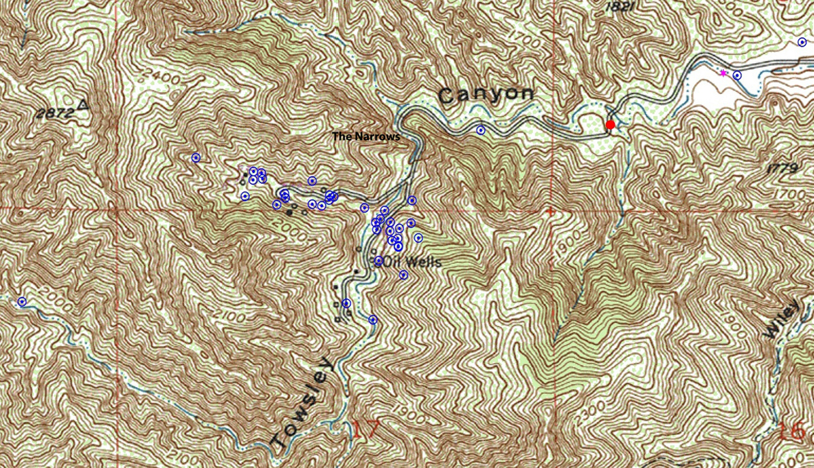
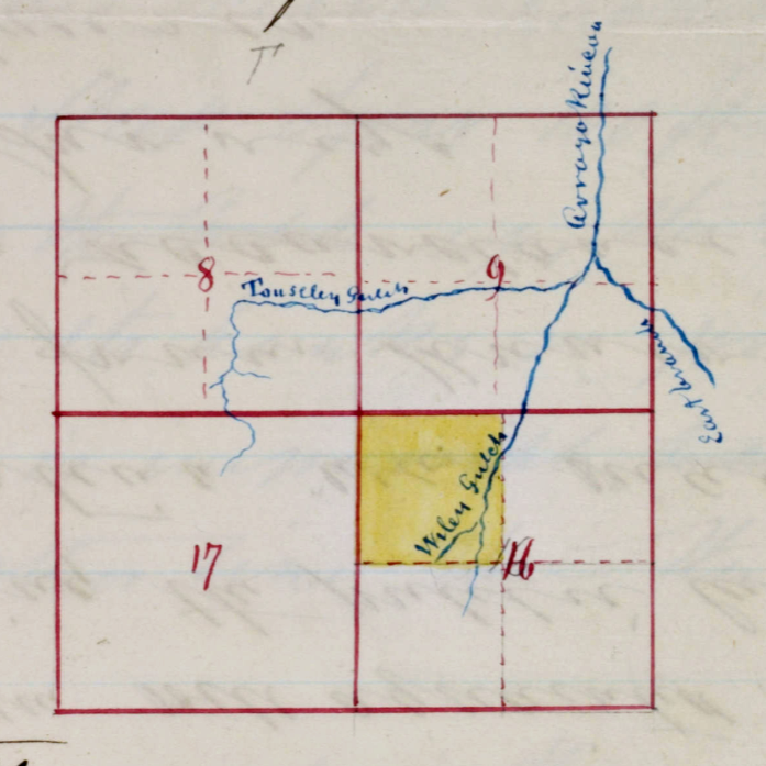
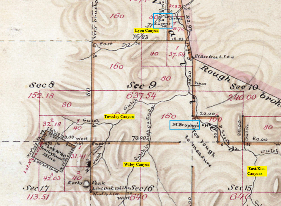
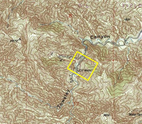
"Coming futher southeast, we reach the Temple claim, where Messrs. Gregory & Co. are sinking a well with every prospect of success. The claim is a fine one, and was bored upon years ago to a depth of five hundred and thirty five feet, the well being full of oil, but the process and tools used in that day were a primitive kind, too small and light for the work, much like constructing a barn with a jacknife. Yet credit is due to the late Mr. Temple for what he did do, for he demonstrated that it was there in quantity..."
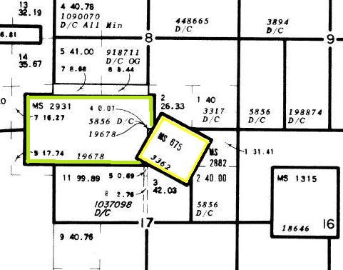
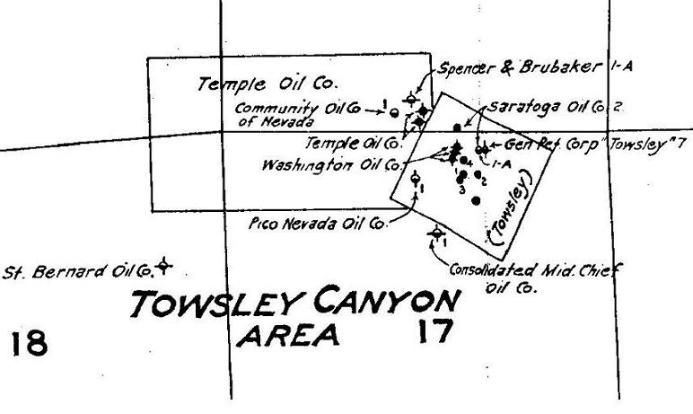
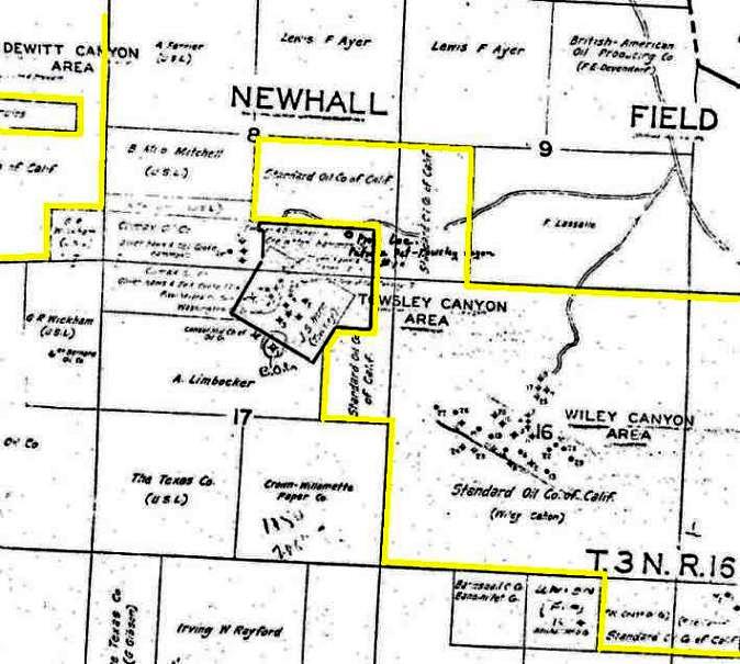
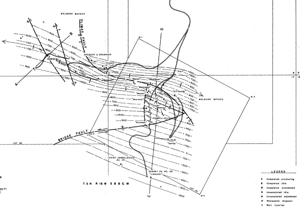
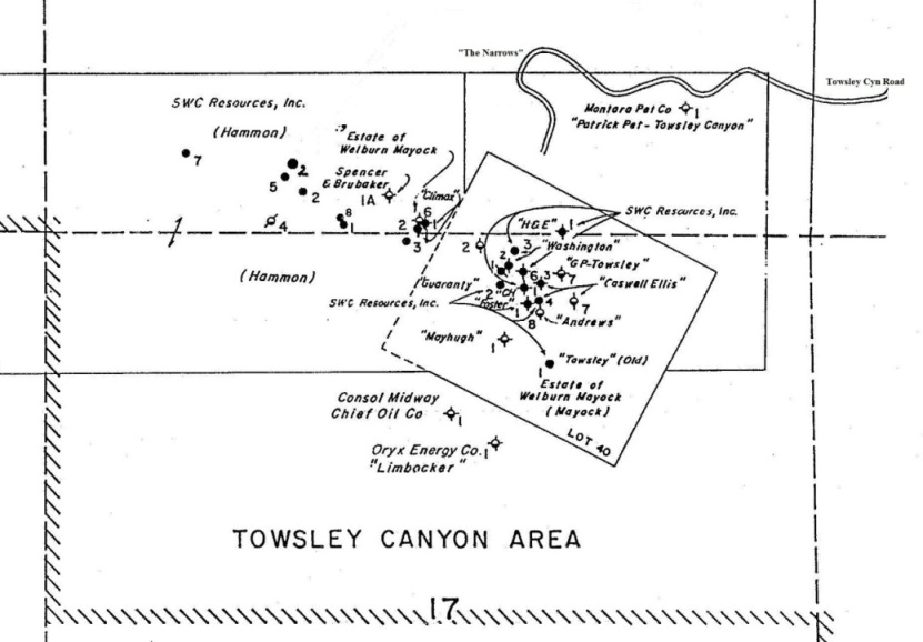
| Well No. | Operator | Year 1st Drilled | Total depth(ft) | Remarks |
|---|---|---|---|---|
| Temple 1 | Temple Oil Co. | Before 1893 | 1079 | Same as Climax 1. No records. |
| Temple 2 | Temple Oil Co. | Before 1893 | ? | Same as Climax 2. No records. |
| Washington 1 | Washington Oil Co. | 1893-94 | 200 | Some heavy black oil |
| Washington 2 | Estate of Welburn Mayock | 1893-94 | 400 | May be Guaranty # 1 |
| Washington 3 | SWC Resources | 1893-1894 | 608 | 12th report of state mineralogist (1894) says that a dark green oil was found and that the company employed 6 men. Rig burned and company (Washington Oil Co) went bankrupt |
| 1 | Clark-Sherman & Co. | 1896 | 900? | No records |
| 1 | Boyle & Thompson | 1897 | 900-1600? | Passed through 6 streaks of oil |
| 1 | Towsley Canyon Oil Co. | 1902 | ? | Crooked hole - a little oil found |
| 1 | St. Bernard Oil Co. | 1903 | 2100 | Oil at several levels but no production |
| 1 | Consolidated Midway Chief Oil Co. | 1913 | 600 | Passed through several oil streaks |
| Towsley 1 (old) | Towsley Canyon Oil Co. | 1915 | 1000? | No records |
| Buick 1 | Buick Oil Co. | 1918 | 1126 | Abandoned 1918 |
| Buick 2 | Buick Oil Co. | 1918 | 1485 | Abandoned 1919 |
| G.P. Towsley 7 | Estate of Welburn Mayock | 1920 | 1293 | Abandoned 1921. Originally drilled by General Petroleum Corp |
| Andrews 8 | Estate of Welburn Mayock | 1922 | 135 | Crooked hole - Owned by Ed Mayhew et al in 1934. Originally drilled by Andrews Oil Co. |
| Mayhugh 1 | Estate of Welburn Mayock | 1925 | 556 | Cement never drilled out of casing - Owned by Pico-Nevada Oil Co. in 1934 |
| Hammon 1 | SWC Resources | 1929 | 5225 | First drilled by Consolidated Oil Co |
| Well No. 1 | Consolidated Midway Oil Co. | 1929-31 | 3270 | Owned by Community Oil Co. of Nevada in 1934 |
| Guaranty 2 | SWC Resources | 1930 | 675 | Producing as of 1934 - Originally drilled by Guaranty Oil Co |
| Caswell-Ellis 3 | Estate of Welburn Mayock | 1932? | 177 | Abandoned 1957. Drilled by Saratoga Oil Co |
| 6 | Saratoga Oil Co. | 1933-34 | 584? | Drilling as of 1934 |
| Caswell-Ellis 4 | Estate of Welburn Mayock | 193? | 552 | Drilled by Saratoga Oil Co |
| Caswell-Ellis 6 | Estate of Welburn Mayock | 1934-35 | 683 | Drilled by Saratoga Oil Co |
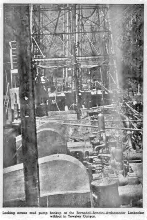
| Limbocker 1 | Oryx Energy Co | 1941-42 | 7056 | Abandoned 1942. Original owner Barnsdall Oil Co |
| H&E 1 | International Oil & Mining | 1944 | 954 | H&E - After Oliver Haws and Joseph Ellsworth the original owners |
| Brown 1 | Parton Transportation Co | 1949-50 | 756 | Abandoned 1950 |
| Foster 1 | International Oil & Mining | 1950 | 3535 | Drilled by Santa Paula Drilling & Development Co |
| Hammon 2 | SWC Resources | 1950 | 4956 | Abandoned |
| Hammon 3 | SWC Resources | 1952 | 2525 | First drilled by Keystone Oil Development Co |
| Brown 1 | M.R. Peck & Sons | 1955 | 796 | Abandoned 1956 |
| Hammon 4 | SWC Resources | 1955-56 | 889 | 1957 converted to waste water disposal well |
| Lassale 1 | Sun Drilling Co | 1959 | 8025 | No oil or gas found. Abandoned in 1959 |
| Lassale 2 | Sun Drilling Co | 1959 | 10858 | Did not produce. Abandoned in 1959 |
| Hammon 5 | SWC Resources | 1960 | 650 | First drilled by Rennick-Corwin Associates |
| Hammon 6 | SWC Resources | 1962 | 1488 | First drilled by Tri-state Petroleum, Inc |
| Mayock 1 | Estate of Welburn Mayock | 1962 | 1008 | Abandoned |
| Mayock 2 | Estate of Welburn Mayock | 1964 | 287 | Abandoned |
| Hammon 7 | SWC Resources | 1965 | 698 | Wilburn Mayock operator |
| Hammon 8 | SWC Resources | After 1965 | 280 | First drilled by International Oil & Mining Co |
| Bailey 11 | DCR Bailey | 1966 | ? | Abandoned |
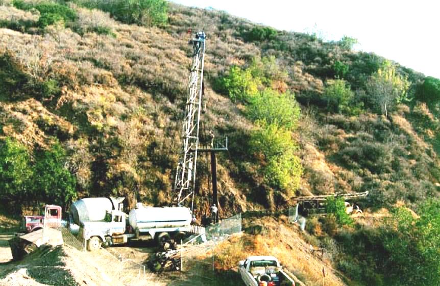
| Patric-Pet-Towsley Canyon 1 | Montara Petroleum Co | 1974 | 8510 | Abandoned 1974 |
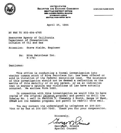
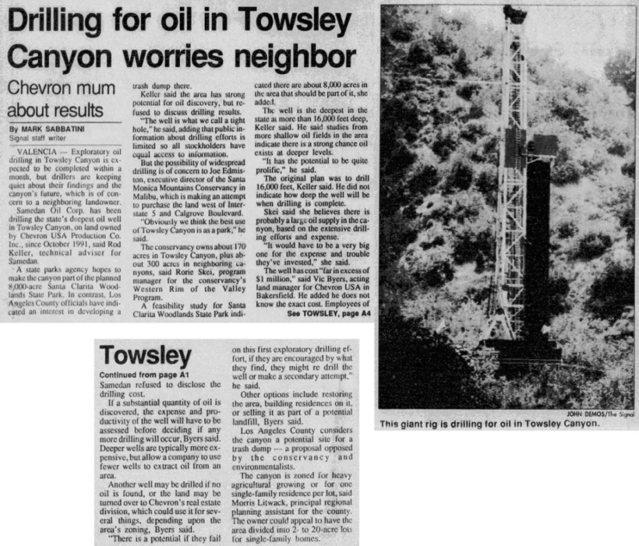
| Chevron-Towsley 1 | Celeron Oil & Gas Co | 1985 | 15816 | Inconclusive results. Abandoned 1987 |
| Chevron-Towsley 1 | Samedan Oil Corp | 1992 | 16114 | First drilled by Celeron Oil Co in 1985. In 1992 hole deeped by Samedan |